The Swiss Alps represent one of Europe’s most challenging and rewarding mountain environments, where proper preparation can mean the difference between an unforgettable adventure and a dangerous ordeal. With over 65,000 kilometres of marked trails traversing landscapes from gentle valley walks to technical alpine routes, Switzerland demands respect and meticulous planning from hikers. The country’s unique combination of rapidly changing weather patterns, high-altitude terrain, and well-developed mountain infrastructure creates both opportunities and challenges that require specific preparation strategies.
Unlike many other mountain ranges, the Swiss Alps feature a sophisticated network of mountain huts, precise trail marking systems, and comprehensive safety protocols that have evolved over more than a century of alpine tourism. However, this infrastructure shouldn’t lull hikers into complacency. The mountains here can be unforgiving, with weather conditions changing dramatically within minutes and terrain that tests even experienced mountaineers. Success in the Swiss Alps requires a comprehensive approach that combines physical conditioning, technical knowledge, and deep understanding of alpine safety principles.
Physical conditioning and Alpine-Specific training protocols for swiss mountain terrain
Preparing your body for Swiss alpine hiking demands a training approach that goes far beyond standard fitness routines. The unique challenges of high-altitude hiking, steep gradient navigation, and prolonged exertion in variable conditions require specific physiological adaptations that take months to develop effectively.
Cardiovascular endurance development for High-Altitude performance above 2,000 metres
Cardiovascular fitness forms the foundation of successful alpine hiking, particularly when venturing above 2,000 metres where oxygen availability decreases significantly. Elite alpine athletes typically maintain a resting heart rate below 50 beats per minute and can sustain aerobic activity for 8-12 hours without significant performance degradation. Building this level of endurance requires progressive training that mimics the demands of mountain environments.
Interval training proves particularly effective for alpine preparation, alternating between high-intensity efforts that simulate steep climbs and recovery periods representing gentler terrain. A typical session might include 6-8 repetitions of 4-minute high-intensity intervals at 85-90% maximum heart rate, followed by 2-minute recovery periods. This protocol develops both aerobic capacity and the anaerobic power needed for technical sections or emergency situations.
Long-duration, low-intensity training sessions should comprise the majority of your cardiovascular preparation, typically 70-80% of total training volume. These sessions, lasting 3-6 hours, develop the metabolic efficiency crucial for multi-day alpine expeditions where energy conservation becomes paramount.
Lower body strength training for steep gradient navigation and scree slope stability
Swiss alpine terrain presents unique biomechanical challenges that standard gym equipment cannot adequately simulate. Steep ascents averaging 15-25% grade test quadriceps endurance, while technical descents on loose scree demand exceptional eccentric strength and proprioceptive control. Research indicates that alpine hikers experience muscle forces 3-4 times greater during steep descents compared to level walking.
Single-leg exercises prove particularly valuable for alpine preparation, as they replicate the uneven loading patterns common on mountain terrain. Bulgarian split squats, single-leg deadlifts, and step-ups with varying heights and surfaces develop the asymmetrical strength patterns essential for navigating irregular mountain paths.
Plyometric training enhances the explosive power needed for boulder hopping and sudden direction changes on technical terrain. Box jumps, lateral bounds, and multi-directional hops performed 2-3 times weekly improve both power output and joint stability under dynamic loading conditions.
Balance and proprioception enhancement for via ferrata and exposed ridge walking
The Swiss Alps feature numerous via ferrata routes and exposed ridges where balance and spatial awareness become critical safety factors. Traditional strength training often neglects these neuromuscular qualities, leaving hikers vulnerable on technical terrain where a momentary loss of balance could prove catastrophic.
Unstable surface training using balance boards, foam pads, and suspension trainers develops the proprioceptive responses essential for maintaining stability on uneven alpine terrain. Progressive overload involves adding external resistance, closing eyes, or performing complex movements while maintaining balance.
Multi-planar movement
Multi-planar movement patterns, such as diagonal lunges, crossover step-ups, and rotational core drills, train your body to react instinctively when the ground shifts or a rock rolls underfoot. Incorporating these exercises 2-3 times per week, ideally after your warm-up when the nervous system is fresh, helps develop the subtle stabilising muscles around the ankles, knees, and hips. You can further simulate exposed ridge walking by practising on narrow beams or painted lines, focusing on a relaxed upper body and controlled foot placement while keeping your eyes looking ahead rather than down.
Acclimatisation strategies for altitude adjustment in jungfrau and matterhorn regions
Although many classic Swiss hiking routes stay between 1,500 and 2,800 metres, rapid ascents around Jungfraujoch, Gornergrat or Klein Matterhorn can still trigger mild altitude sickness if you are not prepared. The body typically needs 24–48 hours to adapt to each 600–800 metres of elevation gain above 2,000 metres, primarily by increasing breathing rate and red blood cell activation. Rushing this process by ascending from valley floors straight to high viewpoints and then undertaking strenuous hikes is one of the most common mistakes international visitors make.
A staged approach works best: spend at least one night in an intermediate-altitude village such as Wengen, Mürren, Zermatt or Saas-Fee before pushing higher. On your first full day, choose a moderate T1 or T2 route with 400–600 metres of ascent and monitor for symptoms such as headache, nausea, or unusual fatigue. Hydration is equally important; high-altitude air is dry, and breathing faster accelerates fluid loss, so aim for 0.5–0.75 litres of water every two hours of hiking, adjusting for temperature and effort.
If you plan to combine hiking with summits above 3,000 metres via cable car, follow the principle of “climb high, sleep low” wherever possible. Enjoy the high viewpoints during the day, but descend to sleep in lower villages so your body can recover in denser air. Should you notice persistent symptoms of altitude sickness, the safest and most effective treatment is immediate descent of 300–500 metres; medications and “pushing through” are poor substitutes for losing height, especially in remote alpine areas.
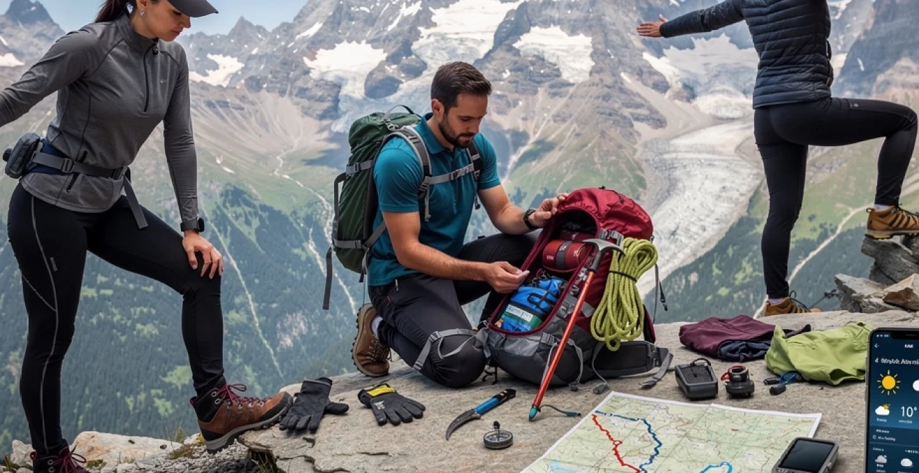
Technical gear selection and equipment specifications for swiss alpine conditions
The Swiss Alps present a unique combination of granite ridges, limestone slabs, snow patches and wet meadows, often in a single day. Choosing the right technical gear is not about buying the most expensive equipment, but about matching your kit precisely to the expected conditions and your chosen routes. From four-season mountain boots to a well-designed layering system, each piece of gear should serve a clear purpose and function reliably when the weather turns or the trail becomes more technical than anticipated.
Four-season mountain boot performance analysis for granite and limestone surfaces
Footwear is arguably the most critical piece of hiking gear in Switzerland, where trails can switch from forest paths to sharp granite blocks and polished limestone steps within minutes. A quality four-season mountain boot offers a stiff midsole for edging on rock, deep lugs for traction on loose scree, and a robust rand to protect against abrasion from jagged stones. Rubber compounds designed for wet rock, similar to those used in approach shoes, can be particularly valuable in areas like the Bernese Oberland where afternoon showers are common.
For multi-day treks on predominantly red-and-white mountain hiking trails (T2 and easier T3), many hikers prefer a lighter three-season boot or sturdy trail shoe with a rock plate and ankle protection. These models reduce fatigue on long days while still providing enough stability for irregular terrain and moderate snow patches. However, if your itinerary includes early-season snowfields, glacier approaches, or blue-marked alpine routes, a semi-rigid boot compatible with crampons becomes essential for safe foot placement and warmth.
When testing boots, simulate Swiss alpine conditions as closely as possible by walking on inclines, stairs, and uneven surfaces with a loaded backpack. Your toes should not hit the front during steep descents, and your heel should remain secure without excessive rubbing. Think of boots as your “interface” with the mountain: if they fail, no amount of fitness or technical skill will fully compensate.
Layering system configuration using merino wool and synthetic insulation technology
Swiss alpine weather is famously changeable; you might start a hike in warm sunshine, encounter cold wind on a pass, and finish the day in drizzling rain. A flexible layering system allows you to adapt quickly without stopping for long periods, maintaining a stable core temperature and preventing both overheating and chilling. At its simplest, this system consists of a moisture-wicking base layer, an insulating mid-layer, and a protective shell, each chosen for specific performance characteristics.
Merino wool base layers excel in this environment due to their ability to regulate temperature and resist odour over multiple days, which is particularly useful on hut-to-hut treks without frequent laundry opportunities. Lightweight, short-sleeve merino tops work well for valley approaches, while long-sleeve versions add sun protection and warmth at altitude. For insulation, synthetic jackets using technologies such as PrimaLoft or similar microfibre fills maintain much of their warmth even when damp, a critical advantage in sudden storms or sweaty ascents followed by windy ridges.
Your outer shell should prioritise weather protection and breathability, with a minimum 20,000 mm waterproof rating and effective ventilation features such as pit zips or two-way front zips. Softshell trousers or durable hiking pants often provide better comfort and mobility than heavy waterproof bottoms, which you can reserve for sustained rain or snow. By thinking of each layer as a “dial” you can turn up or down as conditions change, you’ll remain comfortable and safe across a wide range of Swiss alpine microclimates.
Navigation equipment calibration including GPS units and traditional compass techniques
While Swiss trail signage is among the best in the world, relying solely on yellow signposts and waymarks can be risky in poor visibility, early-season snow, or less-travelled regions. A calibrated GPS unit or smartphone app with offline topographic maps provides precise positioning, but it should always be complemented by a paper map and traditional compass skills. Electronics can fail due to battery depletion, cold, or impact, whereas a map and compass remain functional as long as you understand how to use them.
Before departure, ensure your GPS device or navigation app is loaded with up-to-date Swiss mapping data and that you have downloaded offline tiles for your entire route, including potential escape valleys. Calibrate the compass function and altimeter (if available) at a known elevation, such as a train station or cable car terminal, checking against official altitude markers. During the hike, cross-reference your digital location with the paper map at major junctions; this simple habit significantly improves your terrain awareness and reduces the risk of navigation errors in complex valleys.
Traditional compass techniques, such as taking a bearing to a visible col or peak, remain invaluable in fog, snowfall, or featureless terrain above the treeline. Practise these skills on easier valley routes before you need them in more serious conditions. Think of modern navigation like driving with both headlights and a dashboard: the GPS shows your exact position, while the map and compass help you interpret the broader landscape and plan safe alternatives if the unexpected occurs.
Emergency safety gear requirements for avalanche-prone areas and weather exposure
Even in summer, certain Swiss regions retain steep snowfields, cornices, and residual avalanche risk, especially after late spring storms. If your route crosses or passes beneath such slopes, carrying core avalanche safety equipment—transceiver, probe, and shovel—and knowing how to use them is non-negotiable. For winter and early spring hikes on groomed snow trails, this level of equipment is often unnecessary, but you must still adhere strictly to marked paths and heed local advisories regarding avalanche danger levels.
Beyond snow-specific equipment, every alpine hiker should carry a minimalist but effective emergency kit. At a minimum, this includes a foil rescue blanket, whistle, headlamp with spare batteries, small first-aid kit, and a compact insulation layer such as a lightweight synthetic jacket. In the event of an injury, route blockage, or sudden weather deterioration, these items can make the difference between a cold wait and a life-threatening situation. A fully charged mobile phone with key emergency numbers saved (including local rescue services) completes this basic safety package.
Consider emergency gear as your personal insurance policy against the unpredictable nature of mountain environments. You hope never to use it, but if a storm rolls in over the Jungfrau massif faster than forecast or a companion twists an ankle above a remote valley, you will be relieved you devoted a few hundred grams of pack weight to robust safety provisions.
Backpack load distribution and weight management for multi-day alpine routes
On multi-day treks such as sections of the Via Alpina or the Walker’s Haute Route, your backpack becomes both your mobile home and your primary burden. An optimally fitted pack with 35–45 litre capacity usually suffices for hut-to-hut journeys, while routes requiring tent and cooking gear may demand 50–60 litres. Regardless of size, the key principles are consistent: keep total weight as low as practical (ideally under 10–12 kg for hut-based trips) and position heavy items close to your back and centred between shoulders and hips.
Load the pack so that dense objects such as water, food, and electronics sit mid-height along the spine, with lighter items like sleeping bag liners and spare clothing occupying the top and outer compartments. Hip belts should carry 60–70% of the pack weight, freeing your shoulders and reducing upper body fatigue on long climbs. Take the time to adjust back length, shoulder straps, and load lifters before your trip; a properly tuned backpack will feel like part of your body rather than a separate, awkward load.
Weight management is ultimately about decision-making rather than equipment alone. Ask yourself whether each item justifies its presence by contributing to safety, comfort, or navigation. Redundant clothing, heavy “just in case” gadgets, and oversized toiletry kits are common culprits. By trimming non-essential gear and investing in multi-use items—such as a buff that functions as scarf, hat, or eye mask—you preserve energy for the climbs and descents that make Swiss alpine hiking so rewarding.
Route planning and weather analysis for specific swiss alpine networks
Effective route planning transforms the Swiss Alps from an intimidating maze of peaks and passes into a coherent, safe, and deeply enjoyable hiking experience. With thousands of intersecting trails, multiple language regions, and variable seasonal conditions, investing time in understanding official difficulty ratings, weather patterns, and infrastructure can save you from unpleasant surprises. Whether you are stitching together a week-long journey through the Bernese Oberland or day-hiking from a single base, your strategy should combine objective data with realistic self-assessment.
Trail grade assessment using SAC difficulty scale classifications T1 through T6
Switzerland uses the Swiss Alpine Club (SAC) hiking scale to classify trail difficulty from T1 (easy hiking) to T6 (demanding alpine routes). Most yellow-signed valley and family paths fall into the T1 category, characterised by well-maintained tracks and minimal exposure. Red-and-white mountain trails, which make up the majority of classic alpine hikes, are typically rated T2 or easier T3, involving steeper gradients, rockier surfaces, and occasional use of hands for balance. Blue-and-white alpine routes begin at T4 and progress to T6, requiring advanced skills, route-finding, and often specialised equipment.
When you evaluate a route, avoid focusing solely on distance; in the Swiss Alps, elevation gain and technical difficulty have a far greater impact on how demanding a hike will feel. A 10 km T2 circuit with 300 metres of ascent might suit most fit walkers, whereas a 10 km T3 traverse with 1,200 metres of ascent and descent can challenge even experienced hikers. Consider also your party’s experience with exposure: narrow paths with steep drop-offs can be psychologically taxing even if they are technically straightforward.
As a practical rule, if you have limited mountain experience, start with T1 and easy T2 routes below 2,000 metres, then progressively increase difficulty as your confidence grows. Think of the SAC scale as a “language” that lets you match your ambition to your current abilities; overestimating your capacity on a high T-grade trail can quickly turn an enjoyable hike into a hazardous situation.
Meteoswiss weather pattern interpretation and microclimate variations
Weather in the Swiss Alps is shaped by complex interactions between large-scale systems and local topography, resulting in significant microclimate variations between valleys and even between slopes on the same mountain. The MeteoSwiss service provides detailed regional forecasts, including precipitation, wind, and temperature at various altitudes, but effective interpretation requires a basic understanding of alpine weather behaviour. For example, clear mornings followed by afternoon thunderstorms are common in summer, particularly during hot, humid periods.
Before each hike, consult high-resolution forecasts for both your starting point and the highest col or summit you intend to reach, noting differences in temperature and expected cloud cover. A predicted 20°C in the valley can translate to 8–10°C with wind chill at 2,500 metres, and if rain is forecast, that precipitation may fall as sleet or snow at higher elevations even in July or August. By checking radar imagery and storm warnings on the morning of your hike, you can decide whether to advance your start time, switch to a lower-altitude route, or postpone entirely.
Pay attention as well to on-the-ground indicators: rapid build-up of dark cumulonimbus clouds behind high ridges, sudden wind shifts, or a drop in temperature can all signal approaching storms. In such conditions, exposed ridges, metal via ferrata routes, and open summits become dangerous due to lightning risk. Adopting a conservative mindset and being willing to turn back early is a hallmark of experienced Swiss hikers, not a sign of weakness.
Refuge booking systems and accommodation strategies along popular routes like GR5
On popular long-distance routes such as the GR5 and its Swiss connectors, as well as the Via Alpina or Tour du Mont Blanc, accommodation logistics can be as important as physical preparation. Mountain huts, known as cabane, Hütte or rifugio, often require advance reservations during peak season, especially on weekends and around public holidays. Many now use online booking systems with real-time availability, while others still rely on email or telephone confirmation, so plan to secure critical nights several months in advance.
Structuring your itinerary around hut and village locations allows you to balance demanding days with shorter recovery stages, taking advantage of cable cars or trains when appropriate. For instance, huts close to transport hubs or famous viewpoints tend to fill quickly, whereas more remote refuges with longer approaches may retain last-minute spaces. Paying attention to cancellation policies and deposit requirements helps you adapt plans if weather or trail closures force changes mid-trip.
If you prefer spontaneity, consider travelling in shoulder seasons (late June or early September) and basing yourself in a central village with flexible day-hike options. This approach reduces dependence on hut bookings while still allowing access to classic passes and ridges when conditions permit. As with all aspects of Swiss alpine hiking, realistic expectations and a willingness to adapt will greatly enhance your overall experience.
Alternative route identification for emergency descent in bernese oberland
The Bernese Oberland region, home to icons such as the Eiger, Mönch, and Jungfrau, offers spectacular but sometimes committing terrain. When planning any route here—whether a traverse above Lauterbrunnen, a loop around Grindelwald, or a segment of the Via Alpina—you should identify in advance at least one safe descent option for each major high point. These alternatives might include side valleys with train stations, cable cars, or bus connections that allow rapid return to lower elevations in the event of bad weather, injury, or simple fatigue.
Studying topographic maps before your trip helps you recognise logical escape lines that follow valleys, ridges, or broad shoulders rather than steep gullies or avalanche corridors. Cross-reference these with current transport timetables so you know the last departure times from mountain stations such as Kleine Scheidegg, Schynige Platte, or Mürren. In an emergency, having this information already in mind can save you from rushed decisions made in deteriorating conditions.
Consider also non-emergency scenarios: what if a member of your group is slower than expected, or you encounter residual snowfields that feel beyond your comfort level? Pre-planned alternatives—such as descending to Wengen instead of continuing a full ridge traverse—allow you to maintain safety without sacrificing the entire day. Thinking in terms of “route trees” rather than single fixed lines is a simple but powerful risk management tool in the Swiss Alps.
Alpine safety protocols and risk management in swiss mountain environment
Safe hiking in the Swiss Alps is less about eliminating risk and more about managing it intelligently through preparation, observation, and decision-making. Every route, from a T1 lakeside stroll to a T3 high-level traverse, contains inherent hazards such as slips, rockfall, weather changes, and altitude effects. By adopting structured safety protocols—before, during, and after each outing—you reduce both the likelihood and severity of incidents while preserving the sense of adventure that draws you to the mountains in the first place.
Before departure, conduct a simple risk assessment by asking: What are the objective hazards on this route (steep slopes, snowfields, exposure)? What is the forecast, and how might conditions evolve over the day? How does the route difficulty align with the weakest member of the group, not just the strongest? Writing down your plan, leaving it with someone you trust, and setting a “latest return time” creates an external checkpoint that encourages conservative decisions if things begin to slip behind schedule.
On the trail, maintain situational awareness by regularly checking your progress against time estimates on Swiss signposts and your map. If you find yourself significantly slower than expected before a major climb or exposed section, be willing to shorten the route or use a descent option. Simple habits—such as keeping three points of contact on steep sections, maintaining spacing between hikers in rockfall-prone areas, and using trekking poles effectively—further reduce the risk of common accidents like slips or twisted ankles.
In the event of an incident, Swiss rescue services are highly professional but expect you to have taken reasonable precautions. Know the local emergency number (typically 112 or 144) and be prepared to provide clear information on location, nature of injury, and weather conditions. If you choose to become a patron of Rega, Switzerland’s air rescue service, you support the system and may reduce your financial exposure in the event of a helicopter evacuation, though this is not a substitute for comprehensive travel insurance.
Nutrition and hydration strategies for high-altitude swiss alpine expeditions
Fueling your body correctly is as important as choosing the right boots when it comes to hiking long days in the Swiss Alps. At altitude, energy expenditure increases, appetite can temporarily decrease, and dehydration happens faster due to dry air and accelerated breathing. A strategic approach to nutrition and hydration helps you maintain steady energy, clear decision-making, and efficient recovery between stages, especially on multi-day treks.
As a baseline, aim for a balanced intake of complex carbohydrates, moderate protein, and healthy fats, with total daily energy often reaching 3,000–4,000 calories on demanding days. Breakfast should emphasise slow-release carbohydrates—such as oats, wholegrain bread, or muesli—paired with some protein to stabilise blood sugar. During the hike, consume small snacks every 60–90 minutes rather than relying on large, infrequent meals; nuts, dried fruit, energy bars, and local favourites like dried meat or cheese work well and pack efficiently.
Hydration needs vary, but many hikers underestimate how much fluid they lose in cool, windy conditions where thirst signals are muted. A practical target is 0.5–1 litre of fluid per hour of hiking, adjusted for temperature, altitude, and sweat rate. Using a hydration bladder encourages regular sipping, while carrying a separate bottle allows you to mix electrolyte solutions that replace sodium and other minerals lost through sweat. Clear, pale urine is a simple indicator that you are drinking enough; dark or infrequent urination suggests you should increase intake.
In the evenings, focus on replenishing both glycogen and fluids. Mountain huts and village restaurants often serve hearty, carbohydrate-rich dishes tailored to hungry hikers, from rösti and pasta to soup with bread. While a beer or glass of wine is part of the alpine experience for many, remember that alcohol can further dehydrate you and impair sleep quality; consider alternating alcoholic drinks with water or herbal tea. On multi-day routes, treating nutrition and hydration with the same respect as route planning pays off in sustained performance and reduced injury risk.
Legal requirements and insurance considerations for international hikers in switzerland
Switzerland is renowned for its well-organised infrastructure and clear regulations, and hikers are expected to respect both the natural environment and local laws. While there is no permit system for most hiking routes, you must adhere to restrictions on wild camping, protected areas, and access to private land. In general, bivouacking above the treeline for a single night is tolerated in many regions, but setting up tents near huts, in nature reserves, or on agricultural land without permission can lead to fines or being asked to move on.
For international visitors, comprehensive travel insurance that explicitly covers mountain activities is essential, especially given the high cost of medical care and helicopter rescue in the Alps. Standard policies may exclude off-piste or high-altitude activities, so read the fine print carefully and ensure that hiking up to the maximum altitude you plan to reach is included. Some insurers also differentiate between marked hiking trails and technical climbing or via ferrata routes; if your itinerary includes blue-marked alpine paths or secured routes, confirm that these are covered.
Although not a legal requirement, becoming a supporter of Swiss air rescue organisations such as Rega is a common practice among locals and experienced visitors. For a modest annual contribution, you help fund rescue operations and may receive support with coverage gaps if your insurance proves insufficient, though this patronage is not a contractual guarantee. Finally, remember that by following posted closures, respecting wildlife and livestock, and carrying your rubbish back to the valley, you contribute to preserving the Swiss alpine environment for future generations of hikers.