The art of documenting uncharted territories demands a sophisticated blend of traditional exploration methodologies and cutting-edge technology. Modern explorers face unique challenges when venturing into unmapped regions, from remote Arctic archipelagos to unexplored cave systems beneath established mountain ranges. The documentation process serves not only as a personal record but as a crucial contribution to geographical knowledge and scientific understanding.
Unlike conventional travel writing, territorial exploration requires meticulous attention to detail, systematic recording protocols, and robust verification processes. The difference between a compelling adventure story and valuable scientific documentation lies in the rigour of your methodology and the precision of your observations. Every measurement, photograph, and written account becomes part of humanity’s expanding knowledge base.
Professional exploration documentation has evolved significantly since the era of hand-drawn maps and compass bearings. Today’s territorial explorers must master both digital recording systems and traditional field techniques to create comprehensive records that withstand academic scrutiny whilst maintaining narrative appeal.
Pre-expedition research methodologies for uncharted territory documentation
Thorough pre-expedition research forms the foundation of successful territorial documentation. The process begins months before departure, requiring systematic analysis of existing geographical data, historical records, and indigenous knowledge systems. This preparatory phase determines the scope of your documentation project and identifies specific knowledge gaps your expedition aims to address.
Effective research methodology combines multiple data sources to create a comprehensive baseline understanding. Government geological surveys, satellite imagery analysis, and academic publications provide quantifiable starting points, whilst oral histories and local testimonies offer invaluable contextual information often absent from official records.
Cartographic gap analysis using ordnance survey and satellite imagery
Modern cartographic analysis begins with systematic examination of existing mapping resources. Ordnance Survey data, where available, provides precise elevation models and topographical features, whilst satellite imagery from sources like Google Earth Pro and NASA’s Landsat programme offers recent visual confirmation of territorial characteristics. The key lies in identifying discrepancies between different sources and noting areas where detail becomes sparse or contradictory.
High-resolution satellite imagery analysis requires specialised software and training to interpret geological features, vegetation patterns, and potential access routes. Professional explorers often employ Geographic Information Systems (GIS) software to layer multiple data sources, creating detailed preliminary maps that highlight areas requiring ground-truthing and direct observation.
Indigenous knowledge systems integration through ethnographic interviews
Indigenous communities possess centuries of accumulated knowledge about local territories, including seasonal variations, wildlife patterns, and geographical hazards invisible to satellite imagery. Conducting respectful ethnographic interviews requires cultural sensitivity and often involves working through local interpreters or community liaisons.
Documentation of indigenous knowledge systems should follow established anthropological protocols, ensuring proper attribution and community consent. This information often proves more accurate than official government surveys, particularly regarding micro-climates, water sources, and navigable routes through challenging terrain.
Historical archive mining from royal geographical society collections
Historical archives contain invaluable records of previous exploration attempts, including failed expeditions whose experiences provide crucial safety information. The Royal Geographical Society’s collections, along with national archives and university special collections, house expedition journals, correspondence, and unpublished reports dating back centuries.
These historical documents reveal patterns of environmental change, document wildlife populations over time, and provide baseline data for measuring territorial evolution. Many archives now offer digitised collections accessible remotely, though significant materials remain available only through in-person research visits.
Climate pattern assessment using meteorological station data
Understanding regional climate patterns proves essential for expedition timing and equipment selection. Meteorological station data from national weather services provides historical temperature ranges, precipitation patterns, and extreme weather frequencies. This information helps identify optimal exploration windows and potential seasonal hazards.
Climate data analysis should extend beyond basic temperature and rainfall figures to include wind patterns, fog frequency, and storm tracking. Many regions experience microclimates significantly different from broader regional patterns, requiring careful interpretation of available data and allowances for local variations.
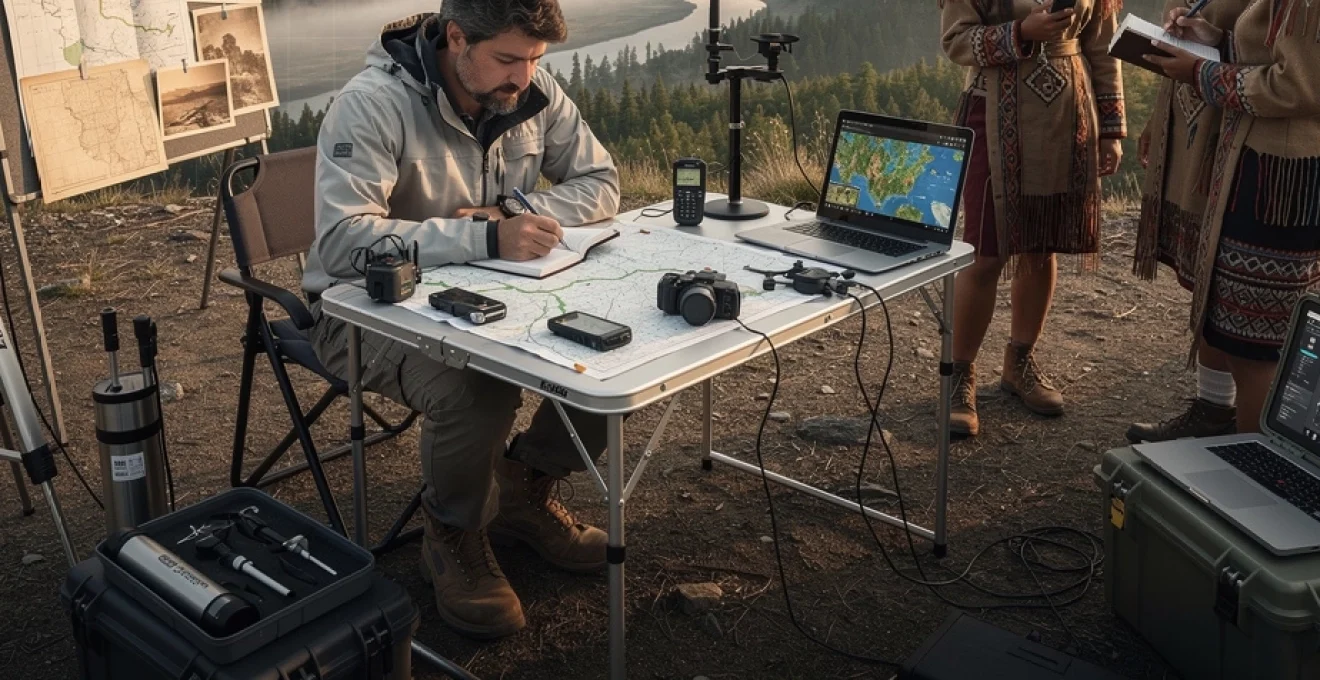
Field documentation equipment and technical specifications for remote exploration
Professional-grade documentation equipment must withstand extreme environmental conditions whilst maintaining precision and reliability. The modern explorer’s toolkit combines traditional instruments with advanced digital systems, creating redundant recording capabilities essential for remote operations. Equipment selection involves balancing functionality, weight
Equipment selection involves balancing functionality, weight, and power consumption. In remote environments where resupply is impossible, every gram and every watt-hour must justify its place in your pack. Whenever possible, choose devices that share power standards (USB‑C, AA batteries) and that can operate offline without constant network access. Redundancy is essential: assume that at least one critical device will fail and plan overlapping systems for navigation, recording, and communication.
GPS coordinate recording with garmin etrex and trimble precision systems
Accurate GPS coordinate recording sits at the heart of any modern exploration narrative that claims cartographic value. Handheld units such as the Garmin eTrex series offer robust, field‑tested performance with long battery life and intuitive interfaces. For high‑precision mapping in unknown territories, survey‑grade Trimble systems can capture positions within centimetres when used with differential correction or post‑processing workflows. The trade‑off is increased cost, complexity, and the need for careful data management once you return from the field.
Before departure, configure your GPS devices using consistent settings: select a common datum (WGS84 is standard for global work), set coordinate format (decimal degrees or degrees–minutes–seconds), and define track logging intervals. Many explorers underestimate how quickly GPS tracks can fill storage; a 5–10 second logging interval usually balances detail with file size for remote expeditions. Always carry paper maps and a baseplate compass as analogue backups, and periodically cross‑check GPS readings against visible landmarks to detect drift or multipath errors in deep valleys, dense forests, or canyon systems.
Environmental data logging through davis weather stations and ph metres
Environmental data transforms a compelling story of exploration into a usable scientific record. Portable Davis weather stations and compact dataloggers can continuously record temperature, humidity, wind speed, and barometric pressure at your base camp, creating a micro‑climate profile for your unknown territory. In river basins, peatlands, or glacial melt zones, hand‑held pH metres and conductivity probes help you document water chemistry, providing crucial context for future hydrological or ecological studies. These measurements also enrich your travel narrative, allowing you to contrast subjective impressions of cold, heat, or storm intensity with quantitative data.
To maintain data quality, calibrate pH metres and other sensors before leaving and again on longer trips whenever calibration solutions are available. Record calibration dates and procedures in a dedicated field notebook; imagine a future researcher reading your notes as carefully as your prose. Where power is limited, prioritise logging critical variables at regular intervals rather than attempting to capture everything continuously. A simple protocol—such as measuring air temperature, water temperature, and pH at each major camp—can be more reliable than an ambitious but unsustainable schedule that collapses once conditions turn hostile.
Photographic documentation using weatherproof camera systems and drone technology
High‑quality photographic documentation helps convey the scale and texture of unknown landscapes in ways that words alone cannot. Weather‑sealed mirrorless or DSLR systems with a limited selection of versatile lenses (for example, a 24–70mm and a 70–200mm equivalent) usually provide the best balance between image quality and portability. Rugged compact cameras or action cams serve as reliable backups when conditions make lens changes impossible—think blowing sand on a desert plateau or spindrift on a high‑altitude ridge. Always protect your gear with dry bags, silica gel packs, and lens filters; in many expeditions, moisture and fine dust are far greater threats than dramatic storms.
Drone technology has revolutionised documentation of uncharted territories, particularly in areas that are physically inaccessible or environmentally sensitive. Lightweight quadcopters equipped with high‑resolution cameras can capture orthomosaic imagery, 3D terrain models, and cinematic establishing shots that anchor your exploration narrative. However, responsible drone use demands pre‑expedition research into local aviation regulations, protected areas, and cultural sensitivities. In some regions, flying over sacred sites or wildlife colonies is not merely illegal but deeply disrespectful. Treat the drone as a surveying instrument first and a storytelling device second, and always log flight paths, take‑off locations, and altitudes for later geospatial analysis.
Audio recording equipment for ambient soundscapes and wildlife documentation
Field audio is often overlooked, yet soundscapes can be as distinctive as any skyline or river bend. Compact audio recorders such as the Zoom H5 or Tascam DR‑40, combined with stereo microphones and basic wind protection, allow you to capture ambient sounds—katabatic winds funnelling through a glacier valley, the layered calls of nocturnal insects, or the first rockfall that hints at shifting permafrost. These recordings not only enrich multimedia presentations but also function as temporal markers in your travel narrative: the exact rhythm of rain on a tent at 3 a.m. tells a different story than a generic mention of “a stormy night.”
For wildlife documentation, directional microphones and parabolic dishes can record bird calls or mammal vocalisations from a respectful distance, supporting later identification by experts. You do not need to be an acoustics specialist; simple protocols such as speaking the time, location, and species (if known) at the start of each recording create metadata that is invaluable during post‑expedition analysis. Always monitor your surroundings as you record—no soundscape is worth compromising your safety or disturbing sensitive species. In many hostile environments, the ability to hear approaching weather or rockfall is as critical as any GPS reading.
Narrative structure frameworks for exploration literature
A robust narrative structure allows you to integrate technical documentation into an engaging travel narrative without diluting the scientific value of your observations. Classic exploration literature often follows a chronological route‑based structure—down a river, across a desert, up a glacier—yet modern readers also respond well to thematic frameworks that interweave geology, climate, and culture. Before you leave, decide whether your primary organising principle will be space (moving across the map), time (a sequence of days and nights), or question (an investigative thread you pursue). This choice will guide what you choose to record and how you prioritise scenes in the field.
One effective approach is the “double track” structure: on one track, you follow the day‑by‑day progress of the expedition; on the second, you periodically step back to present context from pre‑expedition research, indigenous knowledge, or environmental data. Think of it as alternating between the explorer at the campfire and the cartographer at the drafting table. Used judiciously, field notes, coordinate lists, and climate data become narrative turning points rather than dry appendices. Ask yourself: which measurements genuinely alter my understanding of this unknown territory? Those are the ones that deserve space in your story.
Dialogue and character are equally important, even in highly technical exploration writing. Guides, scientists, local elders, and fellow expedition members all offer perspectives that can frame your observations and challenge your assumptions. A short conversation with a hunter about changing ice thickness can carry as much emotional weight as a chart of freeze‑up dates—and the two together are more powerful than either alone. Aim to balance inner reflection, external description, and factual exposition, so that readers feel they are both in your mind and on the ground beside you.
Real-time observation recording techniques in hostile environments
Recording observations in real time while navigating hostile environments is one of the central challenges of documenting unknown territories. Hypothermia, altitude sickness, dehydration, and simple exhaustion all conspire against careful note‑taking. The solution lies in designing documentation routines that are as automatic as tying your boots. Short, frequent entries—snippets of dialogue, quick sketches, weather notes—are far more reliable than ambitious nightly essays that never happen because you are fixing stoves or drying gear. Consider your field notebook an extension of your survival kit: if you have the energy to pitch a tent, you have the energy to write three lines.
In extreme cold or wet conditions, digital devices may fail or be too fragile to use continuously. Write with pencils or all‑weather pens on waterproof paper, and store notebooks in zip‑lock bags close to your body to prevent freezing. Many expedition writers use a layered approach: a tiny pocket notebook for immediate jottings during the day, a more structured journal at camp, and voice memos for moments when writing is impossible. Later, you can triangulate these sources like overlapping GPS tracks to reconstruct a detailed timeline. As with navigation, redundancy is your ally when documenting in extreme environments.
Ask yourself at each rest stop: “What would I forget by tomorrow if I do not write it down now?” That question alone can transform the fidelity of your travel narrative.
Structured observation templates can also help when your cognitive bandwidth is limited. A simple page layout—time, location, weather, terrain, flora/fauna, human activity—encourages you to scan your surroundings methodically, even when distracted by fatigue or danger. Over the course of an expedition, these consistent, almost ritualistic entries generate a rich dataset that can later feed into maps, climate models, or ethnographic studies. In hostile environments, discipline often matters more than inspiration; you may not feel like a writer while hunched in a storm, but future readers will sense the storm’s texture because you persisted.
Post-expedition analysis and verification protocols for geographic discoveries
The most rigorous field documentation still requires careful post‑expedition analysis before your discoveries can enter the wider body of geographical knowledge. Raw GPS tracks, climate logs, and notebooks are only the starting point. Back at your desk, you effectively re‑walk the journey, aligning each entry with coordinates, satellite imagery, and existing maps. This is where the narrative of exploration intersects with the discipline of geography: you are no longer just the protagonist of an adventure but also the first peer reviewer of your own claims.
Cross-reference validation with geological survey data
Cross‑referencing your observations with national and regional geological survey data is essential for establishing the novelty and accuracy of what you have documented. Many geological surveys now provide open‑access datasets, including stratigraphic maps, fault lines, and mineral compositions that you can overlay onto your own GPS files using GIS software. When your descriptions of unknown valleys, cave systems, or river sources align with or expand upon these datasets, you strengthen both your travel narrative and its scientific credibility. Where discrepancies appear, they become focal points for further inquiry rather than simple errors.
In practice, you might import your Garmin or Trimble data into a GIS project and then compare it against digital elevation models and known geological units. Did you traverse a previously unmapped glacier tongue? Does your recorded spring coincide with a predicted aquifer boundary? Treat these questions as narrative opportunities: explaining how your lived experience in the field confirmed or contradicted remote datasets can make for compelling reading. Whenever possible, document your methods of comparison explicitly so that other researchers can replicate or challenge your interpretations.
Peer review submission to geographic and anthropological journals
If your expedition has yielded genuinely new information about an unknown territory—whether physical, cultural, or ecological—formal peer review is the most robust way to validate and disseminate it. Geographic and anthropological journals increasingly welcome contributions that combine narrative fieldwork with rigorous data. Submitting to these outlets requires you to translate your travel narrative into a more structured academic format, with clear methodologies, references, and datasets. This process can feel like swapping a compass for a theodolite: more precise, less romantic, but essential for accurate surveying.
When preparing a manuscript, separate the roles of storyteller and analyst. The most lyrical passages may not fit the constraints of an academic paper, yet the discipline of writing methods and results sections will sharpen your thinking and retroactively improve the clarity of your narrative account. Be transparent about uncertainties and limitations; far from weakening your case, clear acknowledgements of what you do not know enhance the credibility of what you claim to have discovered. A travel narrative that sits alongside a peer‑reviewed article carries far more weight than one that exists in isolation, especially when documenting contentious borders or highly sensitive cultural information.
Digital archive creation for future research accessibility
Creating a digital archive of your expedition materials ensures that your documentation of unknown territories remains accessible long after your book or article is published. At minimum, this archive should include raw GPS files, high‑resolution photographs, scanned field notebooks, audio recordings, and processed maps. Organise these assets with consistent file naming conventions and embedded metadata—dates, coordinates, subjects—so that future researchers can search and reference them efficiently. Think of this as building a well‑indexed library rather than a personal memory box.
Where possible, deposit your archive with institutional repositories, such as university libraries, national archives, or specialist collections at organisations analogous to the Royal Geographical Society. Many offer digital object identifiers (DOIs) for datasets, allowing other scholars to cite your work precisely. Even if you self‑host your materials, regular backups and open formats (such as CSV for tabular data and TIFF for images) will protect your documentation against obsolescence. The more carefully you curate your archive, the more likely it is that your travel narrative will outlive you as a usable contribution to exploration history.
Collaborative mapping integration with OpenStreetMap and academic databases
Once you have verified your geographic discoveries, integrating them into collaborative mapping platforms amplifies their impact. OpenStreetMap (OSM), for example, allows you to add new trails, water sources, settlements, and landforms directly to a widely used global basemap. Academic databases and specialised portals for caves, glaciers, or biodiversity records often provide similar mechanisms for submitting vetted observations. By contributing to these platforms, you transform your solitary expedition into a shared resource for other travellers, scientists, and local communities.
When editing collaborative maps, document your changes thoroughly in the associated notes or change‑set comments. Include details about how the feature was surveyed (GPS, compass, drone imagery), the date of observation, and any relevant local names gathered from indigenous or resident communities. This transparency allows others to assess the reliability of your contributions and prevents common pitfalls, such as over‑generalising from a single season’s conditions. Remember that with collaborative mapping comes responsibility: mis‑placed paths in unknown territories can mislead future visitors in ways that are not just inconvenient but dangerous.
Legal and ethical documentation standards for territory exploration
Documenting the exploration of unknown territories is not only a technical and narrative challenge but also a legal and ethical undertaking. Every new route traced across a glacier, every drone image of a remote settlement, and every recorded oral history carries implications for the people and ecosystems involved. As explorers and writers, we occupy a privileged position; our narratives shape how future travellers, policymakers, and even investors perceive a region. It is therefore essential to ground our work in clear ethical principles and an up‑to‑date understanding of local and international law.
Before entering an unfamiliar region, research land ownership, protected area designations, and any existing access agreements or permits required for scientific work, filming, or drone operations. Many countries have robust frameworks governing archaeological sites, indigenous territories, and national parks; ignorance of these rules is not a defence. Ethically, the principle of “do no harm” should guide every decision: will publishing detailed coordinates of a fragile cave system invite vandalism? Could naming a remote valley popularise a route beyond what its flora, fauna, or local communities can sustain? Sometimes the most responsible documentation choice is strategic vagueness in your published account, coupled with precise records shared only with trusted conservation bodies.
Respect for indigenous knowledge and cultural property is particularly critical in exploration narratives. When communities share place names, stories, or sacred sites, obtain informed consent about how that information will be used, stored, and published. Credit contributors by name or community if they wish, and offer them access to your final work and raw materials. From an ethical standpoint, it is no longer acceptable to treat local expertise as mere background colour in a heroic travelogue. Instead, strive for collaborative authorship of place, acknowledging that you are a temporary visitor in landscapes that others have known for generations.