The most profound travel memories often emerge not from meticulously planned itineraries, but from spontaneous moments when you simply set out on foot and let the destination reveal itself. Walking transforms travel from a checklist of attractions into an immersive narrative where every street corner becomes a potential discovery. While travellers invest considerable time researching landmarks and booking experiences, the humble act of walking frequently delivers the most authentic connection to a place. This phenomenon isn’t merely romanticised nostalgia—it’s rooted in neuroscience, urban design principles, and the fundamental human need for exploration. When you abandon rigid schedules and embrace pedestrian exploration, you unlock layers of a destination that remain invisible from tour buses and taxi windows.
Psychological triggers that transform ordinary strolls into memorable travel experiences
The human brain operates as a remarkably sophisticated reward system during travel, and walking activates multiple neurological pathways simultaneously. Understanding these mechanisms helps explain why a simple stroll through an unfamiliar neighbourhood can eclipse even the most hyped tourist attractions. The psychological architecture supporting these experiences involves complex interactions between sensory processing, chemical releases, and memory formation.
Endorphin release and sensory immersion during urban exploration
Physical movement stimulates endorphin production, creating what exercise physiologists term the “walker’s high”—a gentler cousin of the runner’s high. When you walk for 20-30 minutes, your body releases these natural opioids, elevating mood and reducing stress perception. This biochemical state primes you for positive experiences and enhances receptivity to environmental stimuli. Research from the University of Michigan indicates that urban walking for just 90 minutes can significantly decrease rumination and negative thought patterns compared to indoor activity.
Simultaneously, walking at a leisurely pace—approximately 3-4 kilometres per hour—creates optimal conditions for sensory immersion. Your processing capacity distributes attention across visual, auditory, olfactory, and tactile inputs without overwhelming cognitive resources. Street-level travel exposes you to the aromatic signature of neighbourhood bakeries, the architectural details visible only to pedestrians, and the ambient soundscape that defines local character. This multi-sensory engagement creates richer memory encoding than passive observation from vehicles.
The role of serendipitous discovery in dopamine activation
Dopamine, the neurotransmitter associated with reward anticipation and pleasure, spikes dramatically during unexpected discoveries. Walking through unfamiliar environments creates what neuroscientists call a “novelty-rich context,” where your brain maintains heightened alertness for new information. Each corner turned presents potential surprises—a hidden courtyard, an impromptu street performance, or an intriguing shop front—triggering dopamine release with every revelation.
This neurological response explains why meticulously photographed Instagram locations often disappoint in person, whilst stumbling upon an unmarked local market produces disproportionate joy. The element of unpredictability proves essential. Studies published in the Journal of Experimental Psychology demonstrate that variable reward schedules—where positive outcomes occur randomly rather than predictably—generate stronger emotional responses and more durable memories than scheduled rewards.
Mindfulness walking techniques: from jon Kabat-Zinn’s MBSR to travel applications
Mindfulness-Based Stress Reduction (MBSR) programmes have popularised walking meditation as a therapeutic practice, and these techniques translate remarkably well to travel contexts. The fundamental principle involves directing attention to the immediate physical experience—foot contact with pavement, breathing rhythm, peripheral vision—rather than narrative thought processes. When you apply this approach whilst exploring a new destination, you effectively quieten the internal monologue that often diminishes present-moment awareness.
Travel-adapted mindfulness walking doesn’t require formal training or special settings. You might focus on the sensation of cobblestones beneath your feet in Prague’s Old Town, or consciously notice how humidity feels on your skin whilst walking through Singapore’s streets. This practice combats what psychologists term “destination addiction”—the tendency to mentally skip ahead to the next sight rather than fully experiencing the current moment. Research indicates that even brief periods of mindful walking (10-15 minutes) enhance memory consolidation and emotional well-being.
Cognitive mapping and spatial
mapping describes how your brain builds an internal “sketch” of streets, landmarks, and spatial relationships as you move. In unfamiliar environments, this process becomes especially active, engaging the hippocampus and parietal lobes to integrate visual cues, distances, and directional changes. As you repeat routes or loop back to a central square, your mental map refines itself, making navigation feel easier and more intuitive over time.
This is why a city that seemed disorienting on your first day can feel almost home-like by the third or fourth. Walking slowly rather than rushing between metro stops gives your brain repeated exposure to anchor points—distinctive buildings, public artworks, waterfronts, or parks—that become reference nodes in your spatial memory. Interestingly, research in cognitive psychology suggests that active navigation (choosing turns yourself) leads to stronger spatial memory than passive transport, where routes are predetermined. To maximise this benefit during travel walking, you can occasionally put away your phone and try navigating between two known points using only visible landmarks.
Iconic walking routes that define destination experiences worldwide
While any neighbourhood stroll can become memorable, certain walking routes have evolved into destination-defining experiences in their own right. These iconic paths combine cultural history, landscape design, and walkable infrastructure to create what urban theorists call “experiential corridors.” Walking them is not just about moving from point A to point B; it is about inhabiting a narrative shaped by architecture, nature, and collective memory. When you plan a walking-based trip, incorporating at least one of these emblematic routes can anchor your itinerary and provide a benchmark for other, more spontaneous explorations.
What turns a simple trail or city street into a global reference point for travellers? Typically, it is a combination of aesthetic value, accessibility, and story. From pilgrimage routes dating back centuries to 19th-century engineering marvels and literary haunts immortalised in novels, these walks invite you to step into layers of meaning. They also illustrate how different cultures approach walking as both a practical mode of transport and a ritualised experience.
The philosopher’s path in kyoto: cherry blossom seasonality and cultural significance
The Philosopher’s Path in Kyoto—Tetsugaku no Michi—exemplifies how a relatively short urban walk can encapsulate a city’s soul. Stretching roughly two kilometres along a canal lined with hundreds of cherry trees, the route connects Ginkaku-ji (the Silver Pavilion) with the Nanzen-ji temple area. During cherry blossom season, typically late March to early April, this walkway becomes a living tunnel of pale pink petals, turning an everyday commute for locals into an ephemeral, almost cinematic experience. The seasonality of this spectacle reinforces the Japanese concept of mono no aware, an awareness of impermanence that deepens emotional response.
The path takes its name from 20th-century philosopher Nishida Kitarō, who was said to stroll here in contemplation, and it still functions as an informal outdoor classroom in Japanese aesthetics. As you walk, you pass small shrines, artisan shops, and residential streets, offering glimpses of local life beyond the main tourist thoroughfares. To avoid peak crowds and fully appreciate the reflective quality of the route, consider visiting at dawn or just before sunset on weekdays. Even outside sakura season, the Philosopher’s Path rewards slow walking travel with subtle seasonal shifts—maple leaves in autumn, moss gardens after summer rain, and quiet, snow-muted scenes in winter.
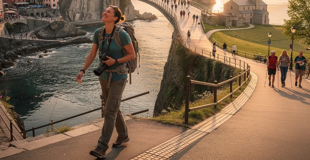
Cinque terre’s sentiero azzurro: coastal trail engineering and UNESCO heritage status
Cinque Terre’s Sentiero Azzurro (Blue Trail) along Italy’s Ligurian coast demonstrates how thoughtful trail engineering can turn rugged terrain into an accessible walking highlight. Linking five historic fishing villages—Monterosso, Vernazza, Corniglia, Manarola, and Riomaggiore—the path hugs cliffs that plunge into the Mediterranean. Cinque Terre is part of a UNESCO World Heritage Site, recognised for its centuries-old terraced vineyards and intricate relationship between human settlement and steep topography. Maintaining walkable access here requires constant investment in retaining walls, steps, and safety barriers to mitigate landslide risks.
Sections of the Sentiero Azzurro periodically close for maintenance or following storm damage, so checking current trail conditions before your trip is essential. The route’s varying difficulty levels—from relatively gentle coastal promenades to steeper stair climbs—make it accessible to walkers with different fitness levels, provided they wear appropriate footwear and carry water. Unlike driving between the villages, which is both limited and environmentally discouraged, walking allows you to appreciate micro-landscapes: hand-built stone walls, wild herbs perfuming the air, and tiny shrines tucked into rock faces. Here, walking is not just a scenic activity; it is the most authentic way to understand how communities adapted to and shaped this challenging coastline.
Brooklyn bridge pedestrian promenade: architectural photography and golden hour timing
The Brooklyn Bridge Pedestrian Promenade in New York City offers one of the world’s most photogenic urban walks, combining 19th-century engineering ingenuity with 21st-century skyline views. Elevated above the vehicle lanes, the wooden walkway grants uninterrupted vistas of Manhattan, the East River, and the Statue of Liberty in the distance. For travel photographers, the bridge functions almost like an open-air studio: its neo-Gothic stone towers and web of suspension cables create natural frames, leading lines, and repeating patterns ideal for minimalist or dramatic compositions alike.
Timing your walk for golden hour—shortly after sunrise or before sunset—dramatically enhances both the visual and emotional impact of the experience. Soft, angled light accentuates architectural details and reduces harsh shadows, while also thinning out the crowds compared to peak midday hours. If you’re planning a walking-based city photo session, a useful strategy is to start in Brooklyn before dawn, walk towards Manhattan as the city lights switch off, and then continue on foot through Lower Manhattan’s historic streets. This way, a single walk becomes a layered travel narrative: bridge, skyline, river, and neighbourhood textures captured within one coherent journey.
Camino de santiago: pilgrimage route planning and credencial stamping logistics
Few walking routes encapsulate the fusion of spiritual intention and long-distance travel quite like the Camino de Santiago. This network of pilgrimage paths across Europe converges at Santiago de Compostela in Spain, with popular routes such as the Camino Francés spanning roughly 780 kilometres from Saint-Jean-Pied-de-Port. Planning a Camino walk involves more than booking flights; you need to consider daily stage lengths, seasonal weather patterns, accommodation in albergues (pilgrim hostels), and rest days to prevent overuse injuries. Many pilgrims aim for 20–25 kilometres per day, but tailoring distance to your fitness and experience is critical.
A central logistical element is the credencial, or pilgrim passport. You obtain it from recognised Camino associations or church bodies and carry it throughout your journey, collecting stamps (sellos) at hostels, churches, cafés, and municipal offices along the way. These stamps verify your route and are required if you wish to receive the official Compostela certificate upon arrival in Santiago, especially if you have walked at least the last 100 kilometres. The ritual of seeking stamps transforms mundane stops into meaningful milestones, punctuating your walking travel with tangible markers of progress. Many walkers later frame their worn, ink-covered credencial as a visual summary of hundreds of kilometres of steps and encounters.
Paris’ left bank literary walk: hemingway’s haunts and shakespeare and company bookshop
On Paris’ Left Bank, a literary-themed walk threads together cafés, apartments, and bookshops associated with writers like Ernest Hemingway, James Joyce, and Simone de Beauvoir. Starting around the Jardin du Luxembourg and heading towards the Seine, you can trace the streets where Hemingway described being “very poor and very happy” in A Moveable Feast. Key stops include Café de Flore and Les Deux Magots, once intellectual hubs for writers and philosophers, as well as the narrow backstreets of the 5th and 6th arrondissements that still retain a village-like atmosphere despite the surrounding city’s scale.
No Left Bank literary walk feels complete without a visit to Shakespeare and Company, the iconic English-language bookshop opposite Notre-Dame. Beyond its shelves and reading rooms, the store functions as a living monument to literary hospitality, historically offering beds to aspiring writers in exchange for help in the shop. For walking travellers, this route demonstrates how a city can be navigated through stories as much as through streets: each plaque, café, and bookshop acts like a hyperlink between physical space and cultural memory. If you carry a journal or e-reader, pausing to write or read a few pages along the way can turn this stroll into your own miniature “moveable feast.”
Urban planning principles that enhance walkability and tourist satisfaction
Behind every memorable walking experience lies an invisible framework of urban planning decisions. Sidewalk widths, crossing times at intersections, the presence of shade or benches, and the mix of ground-floor uses all shape whether walking feels safe, pleasant, or frustrating. For travellers, walkability directly correlates with perceived destination quality: cities that support walking tend to be described as “charming,” “liveable,” or “authentic,” while car-dominated environments feel alienating and hard to explore on foot. Understanding the basics of pedestrian-friendly design helps you recognise why certain places invite lingering strolls and others push you back into taxis.
From a planning perspective, walking-centred cities rely on three pillars: human scale, connectivity, and activation. Human scale ensures that buildings, streets, and public spaces match the dimensions and speeds of people on foot rather than vehicles. Connectivity provides fine-grained route choices, allowing you to detour down side streets, cut through parks, or follow riverfront promenades. Activation refers to the presence of visible activity—shops, cafés, windows, and public art—that gives you something to look at and interact with every 10–20 metres. Where these elements align, walking-based travel becomes both efficient and emotionally rewarding.
Jan gehl’s human-scale city design and pedestrianisation case studies
Danish architect and urban designer Jan Gehl has spent decades studying how people actually use public space, pioneering the concept of “life between buildings.” His research, from Copenhagen to Melbourne and New York, shows that when cities prioritise human-scale design—short blocks, comfortable seating, protected sidewalks—pedestrian volumes and street life increase dramatically. In Copenhagen, for example, the gradual pedestrianisation of Strøget, one of Europe’s longest car-free shopping streets, led to a surge in foot traffic and economic vitality rather than the feared decline.
Case studies like Times Square’s transformation in New York underline how reallocating space from cars to people changes urban walking experiences. Temporary paint, planters, and folding chairs initially tested the concept; when pedestrian satisfaction and retail performance improved, more permanent redesign followed. For walking travellers, these interventions mean wider sidewalks, fewer conflict points with vehicles, and more places to pause, people-watch, or take photos. When you feel comfortable lingering in a square or strolling aimlessly, you are experiencing the tangible impact of Gehl-inspired planning principles on your travel memories.
Wayfinding signage systems: legible london and international best practices
Even the most beautiful streets can feel stressful if you constantly worry about getting lost. Effective wayfinding systems reduce this cognitive load, letting you focus on your surroundings rather than your phone. London’s “Legible London” project is a widely cited example: consistent, map-based signs display “you are here” indicators, walking times to key destinations, and simplified layouts highlighting pedestrian routes rather than traffic flows. Installed across central districts, these signs have been shown to encourage more walking and reduce unnecessary short-distance bus or taxi trips.
Best-practice wayfinding for walking tourism combines visual clarity, multilingual or icon-based information, and strategic placement at decision points—intersections, transit exits, and major landmarks. Some cities supplement physical signage with QR codes or NFC tags that connect to digital walking maps or accessibility information. As a traveller, you can leverage these systems by taking quick photos of area maps at the start of your walk, giving yourself a backup reference if your phone battery dies or GPS signal falters. In destinations lacking formal wayfinding, creating your own “mental signposts”—distinctive buildings or artworks you deliberately note—can provide a similar sense of orientation.
Mixed-use development patterns and street-level activation strategies
Mixed-use development—where residential, commercial, and sometimes light industrial functions coexist—naturally supports walking by shortening distances between daily needs and leisure activities. In tourism districts, this pattern translates into streets where you might pass apartments, bakeries, small offices, and galleries within a single block. This diversity keeps sidewalks active at different times of day, enhancing both safety and interest. In contrast, monofunctional zones like office parks or resort clusters can feel empty and uninviting outside peak hours, discouraging exploration on foot.
Street-level activation strategies further enhance walking appeal. These include outdoor seating, transparent shopfronts, street markets, temporary installations, and performance spaces. Cities like Barcelona and Seoul have experimented with tactical urbanism—low-cost, short-term changes such as parklets in parking spaces—to quickly improve the pedestrian experience. For you as a walking traveller, these activated streets offer constant micro-interactions: glimpses into cafés, conversations with vendors, or spontaneous detours into courtyards and alleys. The street becomes less of a corridor and more of a sequence of small stages, each with its own atmosphere.
Pedestrian infrastructure: pavement quality standards and universal accessibility
The quality of pavement might sound mundane, yet it often determines whether a walk feels effortless or exhausting. Uneven surfaces, sudden curb drops, and poorly maintained tiles not only increase trip hazards but also accelerate fatigue, especially when you carry luggage or walk long distances. Many cities now adopt pavement quality standards that specify minimum widths, smoothness criteria, and tactile indicators for visually impaired users. These standards align with the principle that if a space works for people with mobility challenges, it usually works better for everyone.
Universal accessibility extends beyond ramps and lifts; it encompasses curb radii that slow turning vehicles, audible crossing signals, and adequate crossing times that consider slower walkers. When you plan a walking-heavy itinerary, checking accessibility information becomes crucial if you or your companions use mobility aids or travel with strollers. Even if you do not, you benefit from these design choices in subtle ways: rolling suitcases easily, crossing wide intersections without rushing, or comfortably weaving through crowds without constant vigilance. In this sense, inclusive pedestrian infrastructure is both a social equity measure and a travel quality enhancer.
Photography and content creation strategies for walking-based travel narratives
Walking-based travel naturally lends itself to storytelling. Every turn offers a new frame, every pause an opportunity to capture textures, light, and interactions that would blur past from a moving vehicle. Yet creating compelling visual narratives from your walks requires more than snapping random scenes; it calls for intentional choices about ethics, composition, and how you share locations with your audience. Whether you publish on social media, a personal blog, or professional platforms, aligning your content strategy with the rhythm of your walks can turn casual images into cohesive stories.
Think of your camera or phone as a notebook for visual notes rather than a trophy-collecting device. Instead of aiming for single “hero shots,” consider sequences: wide establishing frames, mid-range context shots, and close-up details. This approach mirrors documentary filmmaking and helps your viewers mentally retrace your steps. It also dovetails with a mindful walking style, encouraging you to slow down and observe changes in light, colour, and human behaviour as you move through the city or landscape.
Street photography ethics: henri Cartier-Bresson’s decisive moment applied to travel content
Street photography during travel raises both creative possibilities and ethical questions. Henri Cartier-Bresson’s concept of the “decisive moment”—capturing a fleeting alignment of elements that reveals a deeper truth—remains influential, but our hyper-shared digital era demands additional care. Photographing strangers without consent may be legal in many public spaces, yet it can feel intrusive or exploitative, especially in communities that experience high tourist pressure. As you document your walking adventures, asking yourself, “Would I be comfortable being photographed this way?” is a simple litmus test.
Ethical street photography on your walks might involve favouring silhouettes, reflections, or wider scenes where individuals are not easily identifiable. When you do want a closer portrait, a friendly gesture or brief verbal request can transform the interaction into a moment of connection rather than extraction. In sensitive contexts—religious ceremonies, schools, or informal settlements—putting the camera away entirely may be the most respectful choice. This ethical awareness not only protects your subjects but also tends to produce more thoughtful, narrative-rich travel photography.
Instagram geotagging tactics for location-based audience engagement
Location tags have become a major driver of how people discover travel content and choose their own walking routes. However, the widespread practice of geotagging exact coordinates has also contributed to overcrowding in fragile spots, from small cafés to remote viewpoints. To balance audience engagement with destination stewardship, many creators now adopt “soft geotagging” strategies—using broader location tags such as a city or region rather than a specific business or hidden trail. This still contextualises your walking stories without turning every quiet corner into a must-see hotspot.
If you want to share precise locations—for example, to support a small local business along your favourite walking route—you can add nuance by pairing the geotag with practical guidance: visiting off-peak hours, respecting local noise norms, or emphasising leave-no-trace principles. Another tactic is delayed posting: share highly sensitive spots days or weeks after you have left, reducing the risk of real-time crowd surges. By treating geotagging as a responsibility rather than a reflex, you help maintain the very authenticity that makes walking-based travel content so appealing.
Vlogging equipment setup: gimbal stabilisation and wireless microphone systems
Filming while walking introduces technical challenges—shaky footage, wind noise, and abrupt exposure changes—that can distract from your story. A compact gimbal stabiliser for your smartphone or camera helps smooth out movement, turning rough steps into fluid tracking shots. Modern three-axis gimbals are lightweight enough to carry all day on city walks, and many offer quick modes for switching between landscape and portrait orientation depending on your platform. As with any gear, the key is to practice before your trip so that setup and calibration become second nature.
Audio quality often matters more than image sharpness for walking vlogs, especially if you speak directly to the camera while moving through noisy environments. Wireless microphone systems—clip-on lavaliers connected to a small receiver on your camera or phone—dramatically improve clarity by isolating your voice from background sounds. Some travellers opt for dual-channel setups, allowing them to record both their narration and ambient city noise on separate tracks for more flexible editing later. With a minimalist kit—gimbal, wireless mic, and a few spare batteries—you can document day-long walking adventures without feeling weighed down.
Safety protocols and navigation technology for solo walking adventures
Solo walking offers unparalleled freedom to set your own pace, follow your curiosity, and change plans on the fly. Yet that same autonomy amplifies certain risks, from getting lost in unfamiliar neighbourhoods to facing medical or security emergencies without immediate support. Rather than letting these concerns deter you, you can treat safety as a design challenge: how do you configure your routes, tools, and habits so that you feel both secure and spontaneous? A combination of navigation apps, communication devices, and cultural awareness forms the backbone of safe solo walking travel.
Before embarking on long or remote walks, letting someone know your intended route and expected return time remains a timeless best practice. In urban contexts, this might be as simple as sharing your live location with a trusted contact; on rural trails, it could mean checking in with guesthouse staff or rangers. Building a small but robust safety routine—charging devices overnight, carrying a power bank, and saving local emergency numbers in your phone—quickly becomes as automatic as lacing your shoes.
Offline mapping applications: maps.me and google maps offline functionality comparison
Reliable navigation is fundamental when you rely on walking as your primary travel mode, yet mobile data and GPS coverage can be patchy or expensive. Offline mapping apps bridge this gap. Google Maps allows you to download large areas for offline use, covering driving, walking, and limited public transit routes, plus saved places like cafés or viewpoints. Directions work without data, although real-time features such as traffic or live business updates do not. The interface is familiar and integrates seamlessly with other Google services, which many travellers find convenient.
Maps.me, by contrast, is built around entirely offline OpenStreetMap data, often including smaller paths, hiking trails, and informal shortcuts missing from mainstream maps. It tends to excel in regions where pedestrian infrastructure is complex or under-documented, such as historic city centres or mountainous areas. One drawback is that search functions can be less forgiving of spelling differences, and business information may be less up-to-date. A hybrid strategy—using Google Maps for planning and address lookups when online, then switching to Maps.me for detailed offline walking navigation—offers resilient redundancy. Downloading map areas for all destinations before departure ensures you are never fully dependent on roaming data mid-walk.
Personal safety devices: GPS trackers and emergency communication tools
For longer or more remote walks, personal safety devices add an extra layer of assurance. GPS trackers and satellite communicators, such as small SOS beacons or satellite messengers, allow you to share your live location and send pre-set or custom messages even without cellular coverage. Some devices include an emergency button that connects to a global monitoring service, which can coordinate rescue efforts with local authorities—a feature particularly relevant for high-elevation treks or sparsely populated regions.
In urban settings, simpler tools may suffice: a compact whistle, a small flashlight, and a portable power bank can make a significant difference in low-probability, high-impact scenarios like power outages or detours after dark. Many smartwatches now incorporate fall detection and emergency call features, automatically alerting contacts if you experience a sudden impact. When choosing gear, balance capability with discretion; devices that blend in with everyday items reduce the risk of drawing unwanted attention while you walk.
Cultural awareness training: dress codes and behavioural norms in conservative destinations
Safety while walking is not only about physical risks; it also encompasses social and cultural dynamics. In conservative destinations, local norms around dress, gender interaction, photography, and public behaviour can differ markedly from what you are used to. Ignoring these unwritten rules may not just be disrespectful—it can inadvertently escalate tensions or attract negative attention. Investing an hour before your trip to research basic cultural expectations pays dividends in smoother, more comfortable walking experiences.
Modest dress codes, for example, might mean covering shoulders and knees in certain neighbourhoods or religious sites, regardless of temperature. Behavioural norms may discourage loud conversations, public displays of affection, or solo wandering late at night in specific districts. Some travellers benefit from short online cultural awareness modules or guide-led orientation walks that explain local etiquette. By approaching your walks with humility and curiosity—observing how locals use public space and following their lead—you not only stay safer but also build more respectful, meaningful connections.
Health metrics and performance tracking for travel walking activities
One of the understated advantages of walking-focused travel is its impact on physical health. Long days on foot can significantly boost your daily step count, cardiovascular fitness, and mental wellbeing, often without feeling like formal exercise. At the same time, tracking basic health metrics helps you avoid overexertion, especially when excitement tempts you to push well beyond your usual activity levels. wearable devices and smartphone apps now make it easy to monitor steps, heart rate, elevation gain, and even sleep quality as you move from city to city.
Seeing tangible data from your walks—10,000 steps exploring a historic centre, 20 flights of stairs climbing to viewpoints—can be both motivating and informative. It allows you to balance ambitious walking days with gentler ones, reducing the risk of injuries like shin splints or plantar fasciitis. If you treat your travel itinerary like a flexible training plan, alternating high- and low-intensity walking days, you can sustain your energy across longer trips while still accumulating rich experiences on foot.
Wearable technology integration: garmin, fitbit, and apple watch comparative analysis
Garmin, Fitbit, and Apple Watch dominate the wearable market for tracking walking and hiking metrics, each with distinct strengths. Garmin devices, particularly the outdoor-focused lines, excel in GPS accuracy, battery life, and detailed elevation tracking, making them well-suited for long-distance trails or multi-day treks. Their mapping capabilities and navigation prompts can function as a backup to smartphone apps, especially when you want to keep your phone battery in reserve for photography or communication.
Fitbit devices prioritise simplicity and health-focused analytics—daily step goals, active minutes, sleep stages—within an accessible interface. For urban walking holidays where you are less concerned with precise route mapping and more interested in general activity levels, this can be more than sufficient. Apple Watch offers deep ecosystem integration, combining fitness metrics with notifications, music control, and safety features like fall detection and emergency calling. Its app ecosystem also supports specialised walking and hiking apps that can log routes, pace, and heart rate zones. Whichever device you choose, synchronising data to a central app lets you review your walking history post-trip, turning numbers into a retrospective map of your travels.
Step count benchmarks and caloric expenditure calculations for different terrains
During travel, it is common to exceed standard activity guidelines without realising it. Public health agencies often cite 7,000–10,000 steps per day as a beneficial target for adults, but walking-centric sightseeing can easily push you to 15,000–25,000 steps, especially in compact cities. Terrain plays a major role in caloric expenditure: a flat 10,000-step day in Amsterdam demands far less energy than the same step count in hilly Lisbon or on a stair-heavy coastal path. Rule-of-thumb estimates suggest that a 70-kilogram person burns roughly 300–400 calories per hour of moderate walking on flat ground, with significantly higher expenditure on steep inclines.
Rather than obsessing over exact numbers, you can use step counts and rough calorie estimates as guardrails. If you are not accustomed to high daily mileage, planning rest breaks every 60–90 minutes and incorporating at least one low-step day per week helps prevent cumulative fatigue. Paying attention to subjective markers—muscle soreness, sleep quality, and morning energy levels—alongside quantitative data offers a more holistic picture of how your body responds to sustained travel walking. After all, the goal is not to maximise steps at all costs, but to align your physical capacity with the kind of immersive, on-foot exploration that makes trips so memorable.
Altitude acclimatisation protocols for high-elevation walking routes
High-elevation walking routes—whether sections of the Camino Primitivo, Andean city walks in Cusco, or Himalayan village trails—introduce an additional physiological challenge: thinner air and reduced oxygen availability. Ascending too quickly can lead to altitude sickness, with symptoms ranging from headaches and nausea to more serious complications. Standard acclimatisation advice recommends not sleeping more than 300–500 metres higher than the previous night once above 2,500 metres, and including rest or “active rest” days where you walk at similar elevations rather than climbing further.
Monitoring your walking intensity becomes crucial at altitude. Wearables that track heart rate can alert you if a pace that feels easy at sea level now pushes you into higher exertion zones, signalling the need to slow down. Hydration and light meals rich in carbohydrates support acclimatisation, while alcohol and heavy exertion on arrival days can exacerbate symptoms. Planning your itinerary with altitude in mind—flying into a mid-altitude city before ascending further, or spending an extra night at intermediate elevations—allows your body to adjust. When approached thoughtfully, high-elevation walks can still become highlights of your trip, offering expansive views and cultural encounters that few vehicle-based tours can match.