Few landscapes on Earth command the same sense of awe as Norway’s western fjords. These monumental geological features—where sheer mountain walls plunge into impossibly deep, narrow channels of seawater—represent nature’s power and artistry at their most compelling. Carved by ancient glaciers during successive ice ages, the fjord systems of western Norway have become synonymous with pristine wilderness, dramatic topography, and a maritime climate that supports surprisingly diverse ecosystems. From the UNESCO-protected waters of Geirangerfjord to the isolated granite plateau of Preikestolen, this region offers an unparalleled combination of natural heritage, cultural history, and accessible adventure that draws over six million visitors annually to a coastline that stretches more than 1,700 kilometres.
Geological formation and glacial morphology of norway’s western fjord systems
The fjords of western Norway owe their existence to processes that began during the Quaternary Ice Age, when massive ice sheets advanced and retreated across Scandinavia multiple times over the past 2.5 million years. These glaciers exploited existing river valleys, deepening and widening them through a combination of abrasion and plucking—geological processes that removed bedrock with relentless efficiency. Unlike typical river valleys with their V-shaped profiles, glacially carved valleys exhibit the characteristic U-shaped cross-section that defines fjord morphology. When the ice finally retreated around 10,000 years ago, rising sea levels flooded these over-deepened valleys, creating the deep-water channels you see today. The result is a landscape where vertical relief often exceeds 1,500 metres within a horizontal distance of less than two kilometres, creating some of the most dramatic coastal scenery found anywhere on the planet.
Quaternary ice age erosion patterns in sognefjorden and hardangerfjorden
Sognefjorden, at 205 kilometres in length and reaching depths of 1,308 metres, represents the ultimate expression of glacial erosion in Norway. During peak glaciation periods, ice thickness over this region exceeded 2,000 metres, generating tremendous pressure at the glacier base that facilitated rapid erosion of the underlying bedrock. The fjord’s extraordinary depth—more than 1,000 metres below sea level in many sections—demonstrates the erosive capacity of thick, fast-moving ice streams. Hardangerfjorden, while slightly shorter at 179 kilometres, displays similar erosional features including over-deepened basins and pronounced threshold ridges that separate the fjord into distinct compartments. These morphological characteristics reflect variations in ice flow velocity and bedrock resistance that occurred during successive glacial advances.
U-shaped valley development and submarine bathymetry characteristics
The cross-sectional geometry of Norway’s fjords reveals important information about glacial dynamics. Classic U-shaped profiles develop when glaciers occupy valleys for extended periods, with ice thickness sufficient to erode valley walls as well as floors. Bathymetric surveys of Sognefjorden show that the deepest sections occur not at the fjord mouth but rather 50-80 kilometres inland, where ice accumulation and flow velocity reached maximum values. This over-deepening creates submarine basins that can be 400-600 metres deeper than the threshold sills near fjord entrances. The sills themselves—submerged ridges of more resistant bedrock—significantly influence water circulation patterns, creating distinct water masses with different temperature and salinity characteristics above and below threshold depth.
Threshold formation and hanging valley networks in geirangerfjord
Geirangerfjord exemplifies threshold development at its most dramatic. The fjord entrance features a pronounced sill at approximately 150 metres depth, while inner basins reach 260 metres. This configuration creates restricted water exchange that influences marine ecology throughout the fjord system. Equally impressive are the numerous hanging valleys that characterize Geirangerfjord’s sidewalls—tributary valleys whose floors lie hundreds of metres above the main fjord level. These features form when smaller tributary glaciers, unable to erode as deeply as the main ice stream, leave valleys perched high above the post-glacial valley floor. Today, streams occupying these hanging valleys cascade down the fjord walls as spectacular
ribbon-like waterfalls. Many of Geirangerfjord’s most famous cascades, including the Seven Sisters and Suitor Falls, originate in these hanging valleys, where meltwater and groundwater plunge hundreds of metres before reaching the fjord surface. For geologists, these sheer drops are visual markers of differential erosion rates between the main trough and its tributaries; for visitors, they are among the most photogenic features of Norway’s western fjords.
Bedrock composition: precambrian gneiss and caledonian mountain range influence
The structural framework of Norway’s western fjords is rooted in some of the oldest rocks on the planet. Much of the region is underlain by Precambrian gneiss, more than 1 billion years old, which provides the hard, erosion-resistant foundation that allowed glaciers to carve such steep walls without catastrophic collapse. This gneiss, often strongly foliated and banded, controls joint patterns and fracture networks that guided glacial flow and modern-day cliff morphology. Superimposed on this ancient basement are remnants of the Caledonian mountain belt, formed when continental plates collided some 400 million years ago, further strengthening the crust and elevating the landscape to heights that made intense glaciation possible.
In practical terms, this bedrock composition explains why Norway’s western fjords differ so markedly from softer-rock coasts elsewhere in Europe. Where sedimentary rocks might crumble into broad, low-relief shorelines, Norway’s crystalline basement supports near-vertical escarpments rising straight from the sea. The combination of gneiss, schist and granite also influences slope stability and rockfall frequency—factors that modern engineers must consider when building roads, tunnels and viewpoints along the fjord margins. For you as a traveller, that deep geological history translates into the clean, angular profiles and towering granite faces that define iconic locations like Kjerag and Preikestolen.
UNESCO world heritage fjord landscapes: geirangerfjord and nærøyfjord
Two of Norway’s western fjords—Geirangerfjord and Nærøyfjord—are recognised by UNESCO as World Heritage Sites, a testament to both their outstanding natural beauty and their cultural significance. These fjords exemplify what many people imagine when they picture “classic” Norwegian scenery: sharply incised valleys, waterfalls tumbling from hanging valleys, and tiny farms and villages perched improbably on narrow shelves high above the water. While both fjords share a common glacial origin, each has its own character, shaped by differences in width, depth, orientation and human use. Exploring these World Heritage fjords, whether from the deck of a cruise ship or the seat of a kayak, offers one of the most concentrated experiences of dramatic Norwegian fjord scenery.
Vertical relief systems: the seven sisters waterfalls and suitor falls
Geirangerfjord’s vertical relief is perhaps best illustrated by its famous waterfall systems, where water appears to pour directly out of the sky. The Seven Sisters (De Syv Søstrene) consist of seven parallel streams that plunge up to 250 metres from a high plateau down into the fjord. Directly opposite lies Suitor Falls (Friaren), named after the legend of a persistent suitor proposing to the seven sisters across the water. These cascades occupy deeply incised gullies cut into the fjord wall, where snowmelt and rainfall concentrate along zones of weakness in the bedrock.
From a geomorphological perspective, these waterfalls are active agents of erosion, continually deepening their channels and transporting sediment to the fjord floor. From a visitor’s point of view, they are among the most compelling sights in western Norway, changing character dramatically with the seasons. In early summer, when snowmelt is at its peak, the Seven Sisters fan out into a powerful white curtain; by late summer, some strands may reduce to delicate veils. Have you ever wondered why these waterfalls maintain such sheer drops instead of breaking into gentler cascades? The answer lies in the resistant gneiss bedrock and the abrupt transition from hanging valley to over-deepened main fjord basin.
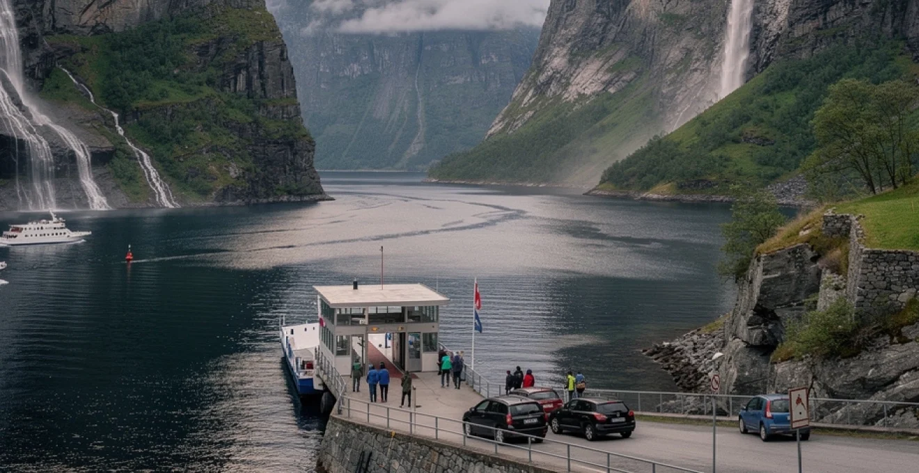
Nærøyfjord’s narrow passage dimensions and navigational constraints
Nærøyfjord, an arm of Sognefjord, is often described as one of the world’s narrowest navigable fjords. In places, it pinches to less than 250 metres across, while cliffs rise more than 1,400 metres on either side. This extreme ratio of depth and width creates a canyon-like environment where ships seem dwarfed by the surrounding topography. Bathymetric data reveal that, despite its narrow surface expression, Nærøyfjord maintains depths of 500 metres or more in some reaches, demanding careful navigation and precise charting.
Modern vessels, including dedicated fjord cruise boats and small expedition ships, rely on advanced GPS, sonar and radar systems to manoeuvre safely in such confined waters. Speed limits, routing regulations and restrictions on vessel size help mitigate wave impact on the shoreline and reduce risks in case of sudden weather changes or rockfall events. For you as a passenger, these constraints are barely noticeable; what you experience is the sensation of gliding through an impossibly tight corridor of rock, often so close to the shore that you feel you could reach out and touch the mountainside. This intimate scale is a key reason why “Nærøyfjord cruise from Flåm” has become a classic long-tail search phrase for travellers planning a Norway fjord itinerary.
Cultural landscape preservation: skageflå and knivsflå mountain farms
While the raw geology of the western fjords draws much of the attention, the cultural landscape—especially the mountain farms—is an integral part of the UNESCO inscription. Farms such as Skageflå and Knivsflå, clinging to narrow ledges high above Geirangerfjord, testify to centuries of human adaptation to a steep, challenging environment. Historically, these farms were accessible only by narrow paths or by climbing directly up from boats, a reminder of how fjords functioned as the primary transport corridor long before modern roads and tunnels.
Today, guided hikes to Skageflå combine cultural history with panoramic views of the Seven Sisters and the main Geiranger valley. Restoration efforts, often led by local heritage organisations, aim to stabilise buildings and prevent the loss of traditional constructions in wood and stone. As you walk among the old byres and farmhouses, it becomes clear that the story of the Norwegian fjords is not just about glaciers and bedrock, but also about families who carved out a livelihood on terraces barely wider than a modern footpath. Preserving these sites helps maintain the delicate balance between tourism development and the authentic character of the World Heritage fjord landscapes.
Seasonal meltwater dynamics and ephemeral cascade formations
One of the most striking aspects of Norway’s western fjords is how different they look from season to season, largely due to changing meltwater dynamics. In late spring and early summer, rising temperatures unleash snowmelt from high plateaus and mountain basins, feeding hundreds of ephemeral cascades that appear almost overnight on the fjord walls. Many of these streams are plunge pools in the making, carving small niches at the base of the cliffs and contributing to ongoing slope modification. By late summer or early autumn, many of these temporary waterfalls diminish or vanish, leaving only the largest perennial systems.
For travellers planning a “best time to see Norway’s fjords” trip, understanding this pattern is invaluable. If you dream of fjord walls draped in countless waterfalls, a visit between May and early July is ideal. If you prefer calmer conditions and more stable weather for hiking or kayaking, late summer and early autumn are often better, even if the number of visible cascades is reduced. From a hydrological standpoint, these seasonal pulses of fresh water influence fjord stratification, nutrient input and even the distribution of plankton and fish, reminding us that the scenic waterfalls are also vital components of a complex ecological system.
Lysefjord’s geological icons: preikestolen and kjeragbolten rock formations
Further south, Lysefjord showcases a different yet equally dramatic expression of western Norway’s fjord landscape. Here, the focus shifts from hanging valleys and remote farms to two of the country’s most famous rock formations: Preikestolen (Pulpit Rock) and Kjeragbolten. Both features are products of glacial erosion and post-glacial weathering acting on massive granite and gneiss plateaus. Preikestolen is a near-rectangular rock platform that juts 604 metres above Lysefjord, its sheer vertical face forming one of the most recognisable silhouettes in Scandinavian tourism. The plateau’s striking geometry reflects joint-controlled weathering, where vertical and horizontal fractures isolated a block that managed to remain intact while surrounding material eroded away.
Kjeragbolten, by contrast, is a glacially transported boulder wedged in a crevice high above the fjord. Suspended 984 metres over Lysefjord, it illustrates how erratic blocks can become trapped in bedrock fissures as ice retreats. Standing on the boulder is a classic challenge for adventurous visitors, though it demands a good head for heights and careful attention to safety advice. Both sites involve demanding hikes over rocky, often wet terrain, and conditions can change quickly, especially outside the main summer season. If you plan to tackle either trail, check local weather forecasts, wear proper footwear, and allow generous time for ascent and descent—these are not casual strolls, but they reward you with some of the most iconic viewpoints in the entire Norway fjord region.
Nordfjord and sognefjord tributary systems: fjærlandsfjorden and aurlandsfjord
While giants like Geirangerfjord and Nærøyfjord attract much of the attention, smaller tributary fjords branching off Nordfjord and Sognefjord offer equally compelling scenery with fewer crowds. Fjærlandsfjorden, a narrow arm of Sognefjord, reaches deep into a valley dominated by the Jostedalsbreen ice cap, mainland Europe’s largest glacier. This connection between deep fjord and active ice makes Fjærland one of the best places to appreciate the full glacial continuum—from high snowfields to calving glacier tongues and down to the sea. Boat trips along Fjærlandsfjorden reveal classic U-shaped valley profiles and well-developed delta deposits where rivers bring glacial sediment into the fjord.
Aurlandsfjord, another Sognefjord tributary, is famous for viewpoints like Stegastein, which projects out from the mountainside to give a sweeping panorama of the fjord corridor. The village of Flåm, at the head of Aurlandsfjord, serves as a hub for fjord cruises, the Flåm Railway, and activities such as kayaking and cycling. Here, you can experience fjord geomorphology at multiple scales in a single day: descend from high mountain plateaus by train, glide along the fjord surface in a boat or kayak, and hike up to overlooks that reveal the full length of the valley. For travellers seeking a “Norwegian fjords itinerary by train and boat,” the combination of Aurlandsfjord and Nærøyfjord has become a classic, balancing accessibility with genuinely wild scenery.
Maritime climate influence and orographic precipitation patterns along hardangervidda
Norway’s western fjords are not just shaped by ice and rock; they are also continuously sculpted by weather. The region’s maritime climate, influenced by the North Atlantic Current, brings relatively mild temperatures for such northern latitudes and substantial precipitation throughout the year. Nowhere is this more evident than along the western escarpment of the Hardangervidda plateau, where moist air masses from the Atlantic are forced upwards over high terrain, cooling and condensing into rain and snow. This process, known as orographic precipitation, is a key reason why the fjord region is so lush and waterfall-rich, especially in areas like Hardangerfjord that lie directly in the path of prevailing westerlies.
Atlantic weather systems and annual rainfall distribution in bergen region
Bergen, often called the “Gateway to the Fjords,” is also known—somewhat jokingly—as Norway’s rain capital. The city receives on average around 2,250 millimetres of precipitation per year, spread across more than 200 days of measurable rainfall. This high figure reflects Bergen’s position at the interface between the open ocean and steep inland topography. As Atlantic low-pressure systems roll in, they encounter the mountains that frame the city and the inner fjords, triggering intense uplift and heavy showers. In contrast, areas just a short distance inland or in the lee of mountain ranges can receive significantly less rainfall, highlighting the highly localised nature of Norway’s climate patterns.
For visitors, this means that flexible planning and good waterproof gear are essential parts of any western Norway fjord itinerary. You might wake to drizzle in Bergen but find bright skies in the inner reaches of Hardangerfjord or Sognefjord a few hours later. The same atmospheric processes that bring frequent rain also sustain the region’s rich vegetation, from moss-covered rock faces and birch forests to lush orchards in Hardanger. In many ways, the rain is part of the experience—without it, the famous fjord waterfalls and green slopes simply wouldn’t exist in their current form.
Temperature inversion phenomena in deep fjord channels
The great depth and sheltered nature of Norway’s western fjords create unique microclimatic conditions, including frequent temperature inversions. In a typical inversion, colder, denser air settles in the lowest parts of the valley or fjord, while warmer air overlies it. On clear, calm days, especially in winter and early spring, this can lead to layers of fog or low cloud trapped in the fjord basin while surrounding mountaintops bask in sunshine. From above, you might look down on a seemingly solid white blanket filling the fjord, with only the highest peaks and ridges emerging like islands.
These inversions have practical implications for both navigation and day-to-day life in fjord communities. Reduced visibility on the water can complicate ferry operations, while higher concentrations of moisture and, occasionally, pollutants may accumulate in the lower layer. For travellers, inversions can create magical visual effects: shafts of light piercing through fog, frost patterns on trees and rocks, and sudden, dramatic clearings as the sun warms the air and the inversion breaks. If you are keen on photography, planning a winter or shoulder-season visit to experience these atmospheric conditions in the deep fjords can be particularly rewarding.
Vegetation zonation from coastal to alpine ecosystems
As you travel from the outer coast to the inner fjords and up towards the high plateaus, you cross a series of distinct vegetation zones, each reflecting subtle changes in temperature, moisture and exposure. The outermost islands and skerries often support hardy, salt-tolerant plants and low shrubs adapted to strong winds and salt spray. Moving inland along the fjords, conditions become more sheltered and slightly warmer, allowing mixed forests of birch, pine and spruce to take hold on lower slopes. In particularly favourable microclimates, such as the inner Hardangerfjord, fruit orchards thrive, producing apples, cherries and plums that have become a hallmark of the region’s culinary identity.
Above the tree line—typically between 800 and 1,100 metres depending on latitude and exposure—alpine heath and tundra dominate, with dwarf shrubs, grasses and mosses clinging to thin soils. On Hardangervidda, one of Europe’s largest mountain plateaus, this high-altitude zone stretches for hundreds of square kilometres, providing habitat for reindeer, ptarmigan and specialised plant species. For hikers, this vertical zonation means that a single day’s walk can take you from leafy coastal forests through birch woodland to open, windswept moorland, offering an almost geological cross-section of Norway’s fjord and mountain ecosystems. It’s like fast-forwarding through several climate zones in the space of a few hours’ ascent.
Fjord navigation infrastructure: hurtigruten coastal route and ferry crossing networks
Given the complexity of Norway’s western coastline—with its deep fjords, islands, peninsulas and steep mountains—maritime infrastructure plays a vital role in everyday life as well as tourism. The famous Hurtigruten coastal route, operating since 1893, threads its way along this intricate seascape from Bergen to Kirkenes, serving as both lifeline and scenic voyage. Along the way, Hurtigruten ships enter selected fjords such as Geirangerfjord (in summer) and Hjørundfjord (in shoulder seasons), giving passengers front-row seats to some of the country’s most dramatic landscapes. For many travellers, combining a section of the Hurtigruten route with local fjord cruises offers a comprehensive way to experience Norway’s western fjords by sea.
Complementing the long-distance coastal route is an extensive network of ferries and fast boats that link communities across and along the fjords. Car ferries connect key road corridors where bridges or tunnels would be impractical or prohibitively expensive, while passenger-only catamarans provide rapid services between cities like Bergen and smaller fjord settlements. These connections make it possible to build flexible, multi-stop itineraries that combine urban stays with remote fjord villages, even without a car. When you plan your own Norway fjord travel route, paying attention to ferry timetables and seasonal schedules is essential; some lines run year-round, while others operate mainly in the summer season.
On top of public transport, a growing range of RIB (rigid inflatable boat) safaris, kayak rentals and small-ship cruises allow you to experience the fjords at water level, closer to the cliffs and waterfalls. Safety regulations, pilotage requirements and environmental guidelines govern how vessels of different sizes can use the fjord corridors, helping to minimise wake erosion, disturbance to wildlife and conflicts between commercial and recreational traffic. As visitor numbers continue to grow, Norway is steadily refining its fjord management strategies, from limiting large cruise ship access in certain areas to encouraging cleaner propulsion technologies. For you as a guest, this means that the spectacular scenery of Norway’s western fjords remains not only accessible but also increasingly protected for future generations.