Australia’s Great Ocean Road stands as one of the world’s most spectacular coastal drives, weaving 243 kilometres along Victoria’s dramatic southern coastline from Torquay to Warrnambool. This engineering marvel, built by returned soldiers as the world’s largest war memorial, presents travellers with an extraordinary tapestry of limestone cliffs, pristine beaches, and ancient rainforests. The journey encompasses iconic formations like the Twelve Apostles, charming seaside townships, and diverse ecosystems that showcase Australia’s natural magnificence.
The allure of this coastal odyssey extends beyond mere sightseeing, offering photographers unparalleled opportunities to capture golden hour seascapes, marine wildlife encounters, and geological wonders shaped by millennia of Southern Ocean forces. Strategic planning transforms a simple drive into an immersive experience, allowing travellers to synchronise their journey with optimal lighting conditions, wildlife activity patterns, and seasonal weather variations that dramatically influence both accessibility and photographic potential.
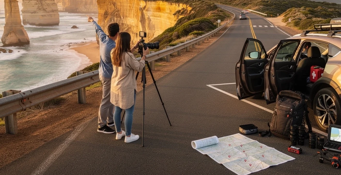
Essential Pre-Journey route planning and vehicle preparation
Successful Great Ocean Road expeditions require meticulous preparation that accounts for the route’s diverse terrain, unpredictable weather patterns, and remote stretches where services become scarce. The winding coastal highway presents unique challenges, from narrow sections carved into clifftops to inland forest passages where mobile coverage disappears entirely. Understanding these variables enables travellers to make informed decisions about timing, equipment, and emergency contingencies.
Seasonal weather patterns and optimal touring windows
Victoria’s coastal climate exhibits remarkable variability, with the Great Ocean Road experiencing what locals describe as “four seasons in one day.” Summer months (December to February) bring peak tourist volumes alongside warm temperatures averaging 20-25°C, though sudden weather fronts can trigger dramatic temperature drops and fierce winds. Autumn offers perhaps the most stable conditions, with March to May delivering mild temperatures, reduced crowds, and excellent visibility for long-distance photography.
Winter touring (June to August) presents both challenges and unique opportunities. Temperatures frequently drop below 15°C, with regular rainfall and occasional fog banks that can obscure coastal viewpoints for hours. However, this season coincides with southern right whale migration, offering spectacular viewing opportunities from headlands near Warrnambool and Portland. Spring (September to November) marks the optimal period for waterfall photography, as winter runoff creates impressive cascades throughout the Otway Ranges.
Vehicle safety inspections and mechanical readiness checklist
The Great Ocean Road’s demanding terrain places significant stress on vehicles, particularly braking systems during the numerous elevation changes and serpentine coastal sections. Comprehensive pre-departure inspections should focus on brake pad thickness, tyre tread depth, and cooling system efficiency. Overheating becomes a genuine concern during summer months when air conditioning systems work overtime and traffic congestion increases engine stress.
Recent statistics indicate that approximately 15% of roadside assistance calls along the Great Ocean Road relate to overheating issues, with the majority occurring between Apollo Bay and Port Campbell during peak summer periods.
Essential maintenance items include checking windscreen washer fluid levels, as salt spray and dust accumulation severely impact visibility. Spare tyre inspection proves crucial, given the remote nature of certain route sections where mobile phone coverage remains unreliable. Emergency kit preparation should encompass basic tools, emergency water supplies, and high-visibility clothing for roadside stops.
Digital navigation tools and offline map download strategies
Mobile network coverage along the Great Ocean Road varies dramatically, with significant dead zones occurring through the Otway National Park sections and remote coastal stretches. Downloading offline maps before departure prevents navigation disasters when GPS signals weaken or disappear entirely. Google Maps offline functionality covers the entire route, while specialised applications like WikiCamps provide detailed information about camping facilities, fuel stations, and emergency services.
GPS accuracy can suffer near clifftop sections due to satellite obstruction, making traditional paper maps a valuable backup resource. The Royal Automobile Club of Victoria (RACV) produces detailed touring maps highlighting scenic lookouts, walking trail access points, and photography locations that standard navigation systems often overlook. Combining digital convenience with analogue reliability ensures navigation continuity regardless of technological failures.
Accommodation
Accommodation booking timeline for peak season travel
Accommodation availability along the Great Ocean Road fluctuates dramatically between off-peak and peak seasons. During summer holidays and long weekends, coastal towns such as Lorne, Apollo Bay, and Port Campbell often reach 90–100% occupancy, with premium rooms booking out three to six months in advance. If you are planning a self-drive itinerary in December or January, secure at least your first and last night’s stays before you finalise flights or car hire.
For shoulder seasons (March–May and September–November), a four to six week booking window is usually sufficient for motels, boutique hotels, and cabins, while campgrounds and caravan parks still benefit from at least two weeks’ notice. Outside holiday periods, it is possible to travel more spontaneously, but even then, popular weekend dates in Lorne and Torquay can fill unexpectedly due to weddings and local events. To balance flexibility with security, many travellers reserve cancellable rates in two or three key hubs and leave intermediate nights open for last-minute adjustments.
Campers should pay particular attention to permits and designated sites, as free camping is heavily restricted along the Great Ocean Road. National park campgrounds and recreation reserves often operate on a limited-capacity, pre-booked system, especially near Cape Otway and Johanna Beach. Treat accommodation planning like a chain: once one night is fixed, ensure the adjacent stops align with your desired driving distances, ideally limiting daily travel to 2–3 hours behind the wheel so you have time to enjoy each scenic stop.
Melbourne to torquay: urban departure and surf coast gateway
The transition from Melbourne’s CBD to the start of the Great Ocean Road offers a gentle introduction to coastal driving before the more dramatic cliff sections begin. Most travellers follow the Princes Freeway (M1) towards Geelong, a dual carriageway that quickly moves you away from city congestion. From here, the landscape shifts to rolling farmland and glimpses of Port Phillip Bay, setting the tone for the maritime heritage and surf culture that define the Surf Coast.
Rather than treating this leg as a mere transit stage, you can structure it as a half-day mini-itinerary. Strategic stops at Geelong’s waterfront precinct and Torquay’s surf hubs allow you to adjust to local driving conditions, stock up on supplies, and explore key coastal viewpoints before officially joining the Great Ocean Road at Torquay. Think of this stretch as your “runway” to the main route: it is where you calibrate your timing, navigation tools, and expectations for the days ahead.
Geelong waterfront precinct and eastern beach reserve
Geelong’s revitalised waterfront provides an ideal first stop 75–90 minutes after leaving central Melbourne. The Eastern Beach Reserve, with its art deco sea baths and expansive lawn areas, offers safe parking, public facilities, and a gentle walkway along Corio Bay. For families, this is a convenient place to break the drive, let children stretch their legs, and enjoy a coffee or early lunch before heading deeper into regional Victoria.
The famous Baywalk Bollards—colourful wooden sculptures lining the foreshore—offer engaging photographic subjects and a light-hearted introduction to the region’s history. From a practical standpoint, Geelong is also one of the last major centres with big supermarkets, pharmacies, and automotive services at metropolitan prices. If you realise you have forgotten sunscreen, a spare memory card, or essential camping gear, this is the most efficient place to fill the gaps before costs rise further along the coast.
Parking near Eastern Beach is generally straightforward outside major events, though weekends can become busy by late morning in warmer months. Arriving before 10am helps you avoid congestion and ensures easier access to waterfront cafes. A 30–60 minute pause here balances rest and exploration without significantly delaying your arrival in Torquay and the official gateway to the Great Ocean Road.
Torquay surf city plaza and australian national surfing museum
Torquay marks the formal beginning of the Great Ocean Road and the spiritual home of Australian surf culture. Surf City Plaza, located just off the Surf Coast Highway, concentrates flagship stores and factory outlets for major surf brands, making it a natural stop for last-minute gear purchases. Whether you need a wetsuit suitable for Southern Ocean temperatures or simply a sun-safe hat, you will find technical equipment and discounted apparel in one compact precinct.
Adjacent to the retail area, the Australian National Surfing Museum traces the development of surfing in Australia, from timber surfboards to modern high-performance designs. Exhibits include historic boards, competition memorabilia, and multimedia presentations that contextualise iconic breaks such as Bells Beach within global surf history. Even if you do not intend to paddle out, this museum provides cultural depth that enriches subsequent stops along the Surf Coast.
Allow 60–90 minutes in Torquay if you plan to visit the museum and browse the outlets; a shorter 30-minute stop may suffice for a quick supply run. Parking can be tight during holiday periods, so consider timing your visit for mid-morning or late afternoon. As you leave Surf City Plaza and head towards the coast, you will begin to sense the subtle shift from urban edge to ocean-facing highway, with road signs and lookout markers signalling your approach to the more scenic segments of the drive.
Point danger marine sanctuary and coastal walking tracks
Just minutes from central Torquay, Point Danger Marine Sanctuary provides your first elevated vantage point over Bass Strait and the broader Surf Coast. A short loop path around the headland connects memorials, interpretive signage, and viewing areas that overlook exposed reefs and consistent surf breaks. On clear days, you can see as far as Point Addis and, in winter, occasionally spot pods of dolphins or seasonal whales offshore.
The sanctuary’s coastal walking tracks offer a low-commitment introduction to Great Ocean Road hiking, with compact distances and relatively gentle gradients. These paths act like a preview reel of the landscapes to come: wind-pruned coastal vegetation, sandstone cliffs, and the ever-present rumble of surf. If you are adjusting to driving on the left or acclimatising after a long flight, a 20–30 minute walk here can reset your focus before you tackle the more demanding coastal bends further west.
Because Point Danger sits on an exposed promontory, conditions can change rapidly; strong onshore winds and salt spray are common. Lightweight windproof layers and secure camera straps are advisable, particularly for photographers shooting seascapes from the cliff edge. After this stop, the route begins to track more closely to the water, with the official Great Ocean Road (B100) leading you towards Anglesea, Aireys Inlet, and the classic cliff-hugging vistas between Lorne and Apollo Bay.
Torquay to apollo bay: limestone cliffs and seaside townships
The section between Torquay and Apollo Bay is often described as the most visually dramatic portion of the Great Ocean Road, especially between Aireys Inlet and Lorne where the highway clings to sheer cliffs above the Southern Ocean. Here, the road’s engineering achievement becomes vividly apparent: carved into rock faces and supported by retaining walls, it delivers continuous views of open water, rocky headlands, and surf-pounded coves. For many visitors, this is where the journey truly feels like a world-class coastal drive.
Key townships punctuate this stretch, each offering distinct character and practical advantages. Anglesea provides relaxed riverfront walks and family-friendly beaches, while Aireys Inlet is known for the Split Point Lighthouse and sweeping headland views. Further west, Lorne functions as both a popular holiday base and an access point to waterfall-rich gullies in the Great Otway National Park. Smaller hamlets such as Wye River and Kennett River offer quieter alternatives, as well as excellent opportunities to spot wild koalas in roadside eucalypts.
From a driving perspective, this segment demands heightened concentration, especially for those unfamiliar with narrow, winding roads. Frequent turnouts and signed lookouts—such as Teddy’s Lookout above Lorne—provide safe places to pause, take photographs, and allow faster vehicles to pass. It is wise to plan only 80–100 kilometres of actual driving per day through this area, given how often you will want to stop for scenic viewpoints, short walks, and township detours. By the time you reach Apollo Bay’s broad crescent of sand, you will have experienced a condensed showcase of the region’s limestone cliffs, surf beaches, and village life.
Apollo bay to port campbell: iconic rock formation corridor
West of Apollo Bay, the Great Ocean Road turns inland, climbing through dense rainforest in the Great Otway National Park before re-emerging at one of the world’s most photographed coastlines. This inland diversion surprises many first-time visitors; instead of continuous ocean vistas, you find yourself under towering mountain ash and tree ferns, navigating shaded hairpin bends. Optional side trips to Maits Rest, Hopetoun Falls, and the Otway Fly Treetop Walk reward those with extra time, showcasing the cool-temperate rainforest that feeds many of the region’s waterfalls.
After passing Lavers Hill and descending towards the coast again, the landscape shifts dramatically. The lush greens of the Otways give way to windswept paddocks and exposed limestone cliffs as you approach Princetown and the Twelve Apostles Marine National Park. This corridor, stretching through Port Campbell National Park to the Bay of Islands, contains the Great Ocean Road’s most iconic rock formations: soaring sea stacks, arches, blowholes, and collapsed caves sculpted by relentless wave action. Because this area draws the highest visitor numbers, timing your arrival and planning your viewing sequence can make the difference between a rushed checklist and a contemplative experience.
Apollo Bay to Port Campbell can be driven in under two hours without stops, but this would sacrifice the very sights that define the route. Instead, many travellers allocate an entire day for this leg, combining inland rainforest walks with multiple coastal viewpoints in the late afternoon and at sunset. By staging your day so that you reach the Twelve Apostles and Loch Ard Gorge outside peak coach-tour hours, you can experience these formations with fewer crowds and far more atmospheric light.
Twelve apostles marine national park viewing platforms
The Twelve Apostles viewing complex serves as the centrepiece of the rock formation corridor, with elevated boardwalks providing multiple perspectives on the offshore stacks. Despite the name, there were never twelve distinct pillars visible from the main lookouts; currently, seven primary stacks remain standing, their bases constantly undercut by wave energy. Visitor numbers here can exceed 10,000 per day in peak periods, so crowd management and parking logistics have become integral parts of the experience.
To maximise your visit, consider arriving at sunrise or within the final hour before sunset, when low-angle light accentuates the stratified limestone and often paints the sky in pastel tones. Midday visits, while still impressive, tend to suffer from flatter light and peak crowd densities as day tours from Melbourne converge on the site. The main car park sits on the inland side of the highway, with a pedestrian underpass delivering you safely beneath the Great Ocean Road to the clifftop paths.
Facilities include toilets, a visitor information area, and basic refreshments, but there is no direct beach access from the primary Twelve Apostles lookout. For that, you will need to continue a short distance west to Gibson Steps, where a steep staircase (subject to closure in severe weather) allows you to stand at sea level and gaze back at the towering cliffs and adjacent stacks. Treat this section with respect: rogue waves and strong currents are common, and signage reflects genuine hazards rather than mere caution.
Loch ard gorge historical shipwreck site
Just a few minutes’ drive from the Twelve Apostles, Loch Ard Gorge offers a more intimate encounter with the region’s maritime history and coastal geology. Here, a sheltered beach nestles between vertical limestone walls, accessible via a staircase from the clifftop car park. The site commemorates the 1878 wreck of the clipper ship Loch Ard, from which only two survivors—Tom Pearce and Eva Carmichael—reached the shore. Interpretive panels along the paths recount their story, anchoring the dramatic scenery in human experience.
Several short walking tracks radiate from the main car park, each leading to distinct viewpoints such as The Razorback, Thunder Cave, and Island Arch. These formations reveal different stages of coastal erosion: from headlands gradually separated from the mainland, to arches, and eventually isolated stacks destined to collapse. Visiting two or three of these lookouts takes 45–60 minutes and delivers a much richer understanding of how time and wave energy sculpt the Shipwreck Coast.
Because Loch Ard Gorge spreads visitors across multiple trails and viewing platforms, it often feels less congested than the Twelve Apostles, even during busy periods. Nonetheless, arriving earlier in the day or closer to sunset still pays dividends in softer light and calmer conditions. Strong onshore winds can funnel through the gorge, amplifying wave noise and spray, so waterproof layers and lens cloths are useful accessories for photographers and casual visitors alike.
London bridge and the grotto geological formations
Continuing west past Port Campbell township, London Bridge (officially renamed London Arch after a partial collapse in 1990) exemplifies the transient nature of limestone coastal features. Once a complete double-span bridge connected to the mainland, it now stands isolated offshore, a reminder that today’s viewpoints may look very different to future generations. Viewing platforms perched on the remaining cliff edge provide safe vantage points, while interpretive signs recount the dramatic collapse that left two visitors stranded on the newly separated arch until they were rescued by helicopter.
A short drive further, The Grotto combines the characteristics of a sinkhole, arch, and tidal pool in a single compact site. A timber staircase descends from the car park to a lower viewing area where you can frame the ocean horizon through a natural rock “window.” At low tide and in calm conditions, reflections in the still water create striking compositions, though safety barriers are in place for good reason: crossing them exposes you to slippery rocks and unexpected wave surges.
Both London Bridge and The Grotto are best visited when you have enough time to linger—around 20–30 minutes per site—rather than rushing from one photo stop to the next. If your schedule allows, align your visit with late afternoon light, which often bathes the cliffs in warm tones and enhances textural detail. These locations are also less frequented by large tour buses, so they can provide a welcome sense of space after the crowds at the marquee attractions.
Port campbell discovery centre and maritime heritage
Port Campbell functions as the primary service hub within Port Campbell National Park, offering accommodation, dining, and essential supplies within walking distance of a sheltered bay. The Port Campbell Discovery Centre (or local visitor information centre) serves as an interpretive gateway to the broader region, with exhibits detailing the engineering history of the Great Ocean Road, local maritime stories, and contemporary environmental management challenges. Staff can provide up-to-date information on road closures, trail conditions, and optimal times for visiting nearby lookouts.
Engaging with the centre’s displays before or after your coastal explorations can significantly deepen your appreciation of the landscapes you have just photographed. Shipwreck charts and archival photographs illustrate how treacherous this stretch of shoreline has been for mariners, while geological cross-sections explain the layered limestone visible in sea cliffs and stack formations. If you are travelling with children, interactive elements and audio-visual presentations help sustain interest after a long day of outdoor activity.
Port Campbell is also an excellent base for multi-night stays if you intend to revisit the Twelve Apostles or Loch Ard Gorge at different times of day for photography. The compact township encourages walking rather than driving between dinner venues, accommodation, and the main beach, reducing the fatigue associated with constant vehicle use. From here, you are well-positioned to continue west towards the quieter yet equally compelling landscapes around Peterborough, the Bay of Islands, and eventually Warrnambool.
Port campbell to warrnambool: volcanic plains and whale migration routes
West of Port Campbell, the character of the Great Ocean Road subtly evolves. While limestone formations still dominate the seascape—particularly around the Bay of Martyrs and Bay of Islands—the hinterland begins to flatten into the volcanic plains that define much of western Victoria. Dry-stone walls and dairy paddocks replace dense rainforest, and traffic volumes typically decrease as you move beyond the primary day-tour circuit. For those willing to continue, this segment offers both quieter coastal viewpoints and unique wildlife experiences.
The Bay of Islands Coastal Park, stretching from Peterborough to Warrnambool’s outskirts, provides expansive clifftop vistas with fewer barriers and fewer people than the more famous sites to the east. Multiple pull-offs along this route invite spontaneous stops to watch changing light over sea stacks and headlands. Unlike the concentrated infrastructure around the Twelve Apostles, these lookouts often feel more raw and exposed, rewarding careful timing and weather awareness.
Approaching Warrnambool, attention shifts from rock formations to living marine giants. Between June and October, Logans Beach becomes a renowned nursery ground for southern right whales, with purpose-built viewing platforms overlooking the shallow coastal waters. Sightings are never guaranteed, but patient observers frequently witness breaching, tail slaps, and close-in mother–calf pairs. Even outside whale season, Warrnambool offers attractions such as Flagstaff Hill Maritime Village and coastal walking trails that provide context to the Shipwreck Coast name.
Advanced photography techniques for coastal landscape capture
The Great Ocean Road is a natural laboratory for coastal photography, offering everything from minimalist seascapes to complex scenes of cliffs, stacks, and turbulent surf. While smartphone cameras can certainly capture memorable images, more advanced techniques allow you to translate the route’s dynamic range of light and motion into controlled, expressive photographs. Think of each stop not just as a viewpoint, but as a set of compositional and technical challenges to solve.
Planning your photographic approach in parallel with your driving itinerary yields significant dividends. Timing visits to key locations around golden hour, preparing for long-exposure work at select beaches, and understanding when and where drone use is permitted can all influence how you structure your days. With the right preparation, you can move beyond postcard snapshots to create a cohesive visual story of your Great Ocean Road journey.
Golden hour timing calculations for limestone stack photography
Golden hour—the period shortly after sunrise and before sunset—plays a disproportionate role in successful limestone stack photography along the Shipwreck Coast. Low-angle sunlight grazes the cliff faces, emphasising texture and subtly warming the typically cool-toned seascapes. Because of the coastline’s east–west orientation, sunrise often favours locations like Gibson Steps and the main Twelve Apostles lookout, while sunset can be particularly effective at Loch Ard Gorge, London Bridge, and the Bay of Islands.
To calculate optimal arrival times, factor in at least 30–45 minutes of setup before the official sunrise or sunset time published in weather apps. This buffer allows for walking from car parks, scouting compositions, and adjusting to changing sky conditions. Apps such as PhotoPills or The Photographer’s Ephemeris overlay sun paths on maps, making it easier to visualise where light will strike cliffs and stacks at specific times of day and year.
Remember that atmospheric conditions can radically alter the quality of golden hour light. High, thin cloud often produces spectacular colour displays, while heavy overcast may result in a more muted, pastel palette. Rather than chasing clear skies at all costs, embrace the variability—soft, diffused light can be ideal for high-contrast scenes such as white surf against dark rock, where harsh sun would otherwise blow out highlights.
Long exposure seascape techniques and neutral density filter selection
Long exposure techniques enable you to convey the constant motion of the Southern Ocean in a way that a single, fast shutter snapshot cannot. By extending exposure times to one second, ten seconds, or even several minutes, you can transform choppy waves into silky streaks or mist-like veils around the bases of sea stacks. This approach is particularly effective at locations like The Grotto, Gibson Steps, and quieter coves near Peterborough where tripod use is practical.
To achieve these longer exposures in daylight, neutral density (ND) filters are essential. A three-stop ND filter can subtly lengthen shutter speeds for gentle motion blur, while six- and ten-stop filters allow for more dramatic smoothing even under bright conditions. Think of ND filters as “sunglasses for your lens”: they reduce light without altering colour balance, giving you creative control over time. Variable ND filters offer flexibility but can introduce artefacts at wide angles, so fixed-strength filters often yield more consistent results for serious landscape work.
Stability is crucial for long exposures. A sturdy tripod with spiked or rubber feet, depending on the surface, minimises vibration, and a remote shutter release or camera self-timer prevents shake when triggering the shot. Always check tide charts before venturing onto rock platforms or low beaches; a beautifully blurred seascape is not worth compromising your safety. As with all advanced techniques, experiment at less crowded locations first so you can refine your method before tackling headline sites with limited space on viewing platforms.
Drone flight regulations within marine national park boundaries
With their ability to capture unique aerial perspectives of cliffs, arches, and sea stacks, drones are understandably tempting along the Great Ocean Road. However, regulations are stringent, particularly within marine national parks and heavily visited lookouts. In many sections of Port Campbell National Park and the Twelve Apostles Marine National Park, recreational drone use is prohibited without a permit, reflecting concerns about wildlife disturbance, visitor safety, and airspace conflicts with search-and-rescue operations.
Before packing your drone, consult Parks Victoria guidelines and the Civil Aviation Safety Authority (CASA) drone rules for current restrictions. Apps such as “Can I Fly There?” or CASA-verified equivalents provide real-time maps of no-fly zones, including national parks, airports, and built-up areas. Even where drones are technically allowed, you must maintain visual line of sight, keep a minimum distance from people, and respect privacy around residential areas and accommodation.
Ethically, ask yourself whether launching a drone will significantly enhance your storytelling or simply duplicate angles already available from public lookouts. In confined spaces such as Loch Ard Gorge or The Grotto, the noise and presence of drones can severely impact the experience of other visitors. Often, a well-executed series of ground-based images—thoughtfully composed and timed—will prove more satisfying than footage captured in marginal or restricted conditions.
Weather protection strategies for camera equipment in salt air
Coastal environments present a harsh test for photographic equipment: salt spray, fine sand, sudden showers, and strong winds can all conspire to shorten the lifespan of cameras and lenses. Treat your gear much like you treat your vehicle on this trip—regular maintenance and protective habits will pay off over hundreds of kilometres of exposure. Weather-sealed bodies and lenses offer an advantage, but they are not invulnerable; preventative measures still matter.
Simple accessories can make a significant difference. Rain covers or even a lightweight shower cap protect your camera between shots, while microfibre cloths and lens wipes allow you to clear salt residue without scratching front elements. Storing gear in a padded, zippered bag when moving between lookouts reduces the risk of wind-blown sand infiltrating buttons and zoom mechanisms. For long days near the surf, consider carrying a small dry bag inside your main pack as an extra layer of security.
Post-shoot care is equally important. Wipe down exterior surfaces with a slightly damp, fresh-water cloth to remove salt crystals, and avoid changing lenses in exposed, windy conditions whenever possible. If your tripod has been in contact with seawater, rinse the legs with fresh water and extend them fully to dry before storage to prevent corrosion. By integrating these habits into your daily rhythm on the Great Ocean Road, you help ensure that your equipment remains reliable—not just for this journey, but for many adventures to come.