Mexico City’s transportation network stands as one of the most extensive and complex urban mobility systems in Latin America, serving over 21 million residents across the metropolitan area. This sprawling megacity has developed a sophisticated multi-modal transport infrastructure that combines traditional metro systems with modern bus rapid transit, informal microbus networks, and innovative bike-sharing programmes. Understanding how these interconnected systems operate becomes essential for anyone navigating this vibrant capital, whether you’re a daily commuter or a visitor exploring the city’s rich cultural offerings. The sheer scale of Mexico City’s transportation challenge has driven innovative solutions that other major cities worldwide now study and emulate.
Mexico city metro system navigation and route planning
The Mexico City Metro, known locally as Sistema de Transporte Colectivo, represents one of the world’s largest underground railway networks with 12 lines spanning 226 kilometres and serving 195 stations. This extensive system carries approximately 4.5 million passengers daily, making it the backbone of urban mobility in the capital. The network’s distinctive colour-coded lines and pictographic station symbols were designed to assist passengers with varying literacy levels, creating an inclusive transit system that serves Mexico City’s diverse population effectively.
Navigation through the metro system requires understanding both the numerical line designations and their corresponding colours, as well as recognising the cardinal direction indicators that guide passengers to the correct platforms. Each line operates with specific service patterns, with some offering express services during peak hours while others maintain consistent local stopping patterns throughout the day. The system’s efficiency stems from its radial design, which connects outer residential areas with the central business district through strategic transfer points.
Line interconnections at major hubs: pantitlán, tacubaya, and balderas stations
Pantitlán Station serves as the system’s largest interchange, connecting Lines 1, 5, 9, and A, along with several surface transport options including airport connections. This massive terminal processes over 400,000 passengers daily and features extensive commercial areas, making it a destination in itself. The station’s design incorporates multiple levels to separate different transit modes, with clear signage directing passengers through the complex transfer processes between underground metro lines and elevated sections.
Tacubaya represents another critical hub where Lines 1, 7, and 9 intersect, serving as a gateway to western Mexico City neighbourhoods and providing connections to the suburban train network. The station’s strategic location makes it particularly important for commuters travelling between the historic centre and affluent western districts like Santa Fe and Las Lomas. Recent infrastructure improvements have enhanced passenger flow management and reduced transfer times between different lines.
Balderas Station facilitates connections between Lines 1 and 3, positioning itself as a key interchange for north-south and east-west travel patterns. The station’s proximity to major commercial areas and government buildings generates substantial pedestrian traffic throughout the day. Its underground passages connect directly to several office towers and shopping centres, creating an integrated urban environment that exemplifies successful transit-oriented development.
Peak hour traffic patterns and carriage capacity on lines 1, 2, and 3
Peak hour operations on Mexico City’s metro system reveal significant variations in passenger density and service frequency across different lines. Line 1, the original pink line connecting Observatorio to Pantitlán, experiences maximum capacity during morning rush hours between 7:30 and 9:00 AM, with trains arriving every 90 seconds. The line’s nine-car trains can accommodate up to 1,800 passengers, though actual loads often exceed this theoretical capacity during peak periods.
Line 2, identified by its blue colour and running from Cuatro Caminos to Tasqueña, demonstrates the system’s busiest corridor with over 1.2 million daily passengers. The line’s strategic route through central Mexico City creates consistent high-demand conditions throughout the day, particularly at stations serving major employment centres like Bellas Artes and Pino Suárez. Train frequency during peak hours reaches every 2 minutes, making it one of the most intensive urban rail operations globally.
Line 3, the olive-green line from Universidad to Indios Verdes, showcases the metro’s role in connecting educational institutions with residential areas. The southern terminus at Universidad serves Mexico’s largest public university, creating unique peak patterns that correspond with academic schedules rather than traditional business hours. This line experiences reverse comm
mute flows in both directions as students travel between campus facilities, residential zones, and cultural hubs along the corridor. Carriage capacity on Line 3 has been progressively enhanced with modern rolling stock featuring improved ventilation and wider doorways to reduce dwell times at stations. As with Lines 1 and 2, dedicated women-and-children-only cars operate during peak periods, providing safer travel options and modestly redistributing passenger loads across the trains.
Digital ticketing integration with CDMX mobility card system
The evolution of fare collection in the Mexico City Metro has centred on the Tarjeta de Movilidad Integrada (Integrated Mobility Card), which now serves as the primary digital ticketing medium across multiple transport modes. This contactless smart card allows passengers to load credit at station kiosks, convenience stores, and automated machines, then simply tap at entry turnstiles to validate their journey. For regular commuters and visitors alike, using a single mobility card eliminates the need to queue for paper tickets, particularly during peak travel hours.
From a systems perspective, the CDMX mobility card integrates metro, Metrobús, light rail, and certain public bike-share services under a unified fare framework. Transaction data captured at each validator helps city planners analyse passenger flows, optimise train frequency, and detect bottlenecks in near real time. For travellers planning complex itineraries across Mexico City’s transportation network, this unified platform acts much like a universal key, unlocking multiple transport options with one simple tap.
Digital ticketing has also paved the way for pilot programmes involving fare capping and time-based passes, designed to make daily travel more predictable and affordable. While not yet universal, these initiatives mirror best practices in other global megacities and signal a gradual shift from flat per-ride pricing to more flexible mobility-as-a-service models. As mobile payment adoption increases, we can expect further integration between smartphone wallets and the existing card-based system, simplifying access for international visitors who may not carry local currency.
Accessibility infrastructure for disabled passengers across network stations
Accessibility across the Mexico City Metro network has improved steadily, though variations remain between older and newer stations. Many of the more recently built or renovated stations feature lifts, ramps, tactile paving, and widened turnstiles designed to accommodate wheelchairs and mobility devices. Audio announcements and visual displays inside carriages and on platforms assist visually and hearing-impaired passengers, ensuring they can identify upcoming stops with greater confidence.
Legacy infrastructure, particularly on the earliest lines, still presents challenges such as long staircases, narrow corridors, and limited step-free access. To mitigate this, the city has prioritised upgrades at high-traffic transfer hubs, where accessible pathways can benefit the greatest number of disabled passengers. As you plan journeys that require step-free access, it is advisable to consult official station maps or accessibility guides in advance, much as you would check a building’s fire exits before entering.
Special assistance services are available at selected stations, where staff can help passengers navigate transfers or board trains safely. Designated priority seating in each carriage supports not only disabled travellers but also older adults, pregnant women, and people travelling with young children. While the system is not yet barrier-free in the way that some newer metros are, ongoing investment and policy attention signal a clear commitment to inclusive mobility within Mexico City’s public transport ecosystem.
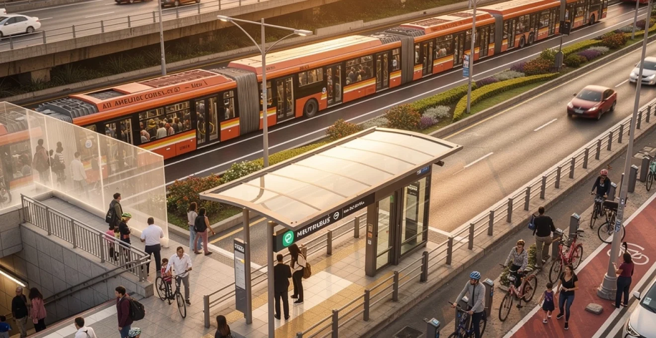
Metrobús rapid transit corridors and BRT operations
Complementing the metro system, the Metrobús network operates as a bus rapid transit (BRT) system that runs along dedicated corridors throughout Mexico City. Launched in 2005, Metrobús now covers over 140 kilometres across multiple lines, carrying more than 1.5 million passengers daily. Think of it as a surface-level metro: buses run in segregated lanes, stop at enclosed stations with platform-level boarding, and follow high-frequency schedules designed to reduce travel times along key avenues.
For passengers, Metrobús provides a crucial east–west and north–south link where metro coverage is limited or where demand exceeds underground capacity. The system uses the same Integrated Mobility Card as the metro, enabling seamless transfers between modes without purchasing separate tickets. Because stations are spaced more widely than traditional bus stops, Metrobús can maintain higher average speeds, especially along congested arteries like Avenida Insurgentes and Paseo de la Reforma.
Line 1 insurgentes corridor: station spacing and express service patterns
Line 1 of Metrobús, running along Avenida Insurgentes, serves as the backbone of the BRT network and one of the longest bus corridors in the world. Stretching from Indios Verdes in the north to El Caminero in the south, it connects residential districts, business centres, and university areas with a mix of local and limited-stop services. Station spacing along this corridor typically ranges from 400 to 800 metres, a deliberate compromise between accessibility and journey speed.
During peak hours, Line 1 operates express patterns where certain buses skip lower-demand stops to reduce travel times between major hubs such as Reforma, Buenavista, and La Bombilla. These service tiers function much like express and local subway trains, allowing you to tailor your route depending on whether you prioritise speed or proximity to specific neighbourhoods. On-board displays and station signage clearly differentiate express services, though first-time riders should pay close attention to route numbers and destinations to avoid overshooting their stop.
This corridor is especially valuable for travellers staying in central districts such as Condesa, Roma, and Del Valle who need a reliable alternative to congested surface streets. By using centre-running lanes and platform-level boarding, Line 1 can move large volumes of passengers with metro-like efficiency while maintaining the flexibility of a bus network. For many daily commuters, it has become the default option for traversing the city’s north–south axis.
Dedicated lane infrastructure on reforma and eje central corridors
Beyond Insurgentes, dedicated Metrobús lanes along Paseo de la Reforma and Eje Central form vital spines of Mexico City’s bus rapid transit operations. These corridors carve out protected space for articulated buses in the middle of heavy traffic, shielding them from the stop-and-go conditions that slow conventional buses. The effect is similar to building an elevated rail line above a busy avenue, but with far lower construction costs and greater implementation speed.
On Reforma, Metrobús services connect major tourist attractions, financial districts, and cultural institutions, providing a practical option for visitors who want to avoid taxis or ride-hailing during rush hour. Eje Central, by contrast, serves more densely populated and commercial zones, where the difference between a dedicated lane and mixed traffic can mean saving 20–30 minutes per trip. In both cases, intersection priority signals help maintain bus headways, ensuring that buses spend more time moving and less time idling at red lights.
The presence of physical separators, raised platforms, and clearly marked crosswalks also improves safety for pedestrians and cyclists along these avenues. While drivers may occasionally encroach on bus lanes during off-peak periods, enforcement cameras and traffic police patrols support compliance, preserving the time savings that make BRT an attractive alternative. For urban planners, these corridors serve as living laboratories for congestion mitigation and multimodal integration.
Articulated bus fleet specifications and passenger throughput analysis
The Metrobús fleet consists primarily of articulated and bi-articulated buses designed for high passenger capacity and rapid boarding. Standard articulated units can accommodate around 160 passengers, while bi-articulated models, used on the busiest segments, can carry upwards of 240 people at full load. Multiple wide doors and level boarding platforms enable passengers to enter and exit simultaneously, significantly reducing dwell times at each station.
From a throughput perspective, a well-optimised corridor can move as many as 10,000–15,000 passengers per hour per direction, approaching the lower end of heavy rail metro capacity. This makes Metrobús an efficient solution for corridors where demand is too high for conventional buses but does not yet justify the investment in a full underground line. You can imagine each articulated bus as a train carriage running on asphalt instead of steel rails, linked by a tightly controlled schedule and signalling system.
Modern fleet specifications also incorporate environmental considerations, with many buses operating on cleaner diesel technologies or compressed natural gas. Newer vehicles feature low-floor designs, dedicated wheelchair spaces, and improved ventilation systems to enhance passenger comfort. By aligning vehicle design with station architecture and digital ticketing, the system achieves a level of operational efficiency that would be difficult for traditional surface bus networks to match.
Integration points with metro stations and transfer protocols
A defining characteristic of Metrobús in Mexico City is its deliberate integration with the metro system at key interchange points. Stations such as Buenavista, Hidalgo, and Insurgentes Norte offer direct or short walking connections between BRT platforms and metro entrances, enabling fast transfers across modes. Signage typically indicates which metro lines are accessible from each Metrobús stop, easing navigation for passengers who are unfamiliar with the area.
Transfer protocols are streamlined through the shared use of the Integrated Mobility Card, allowing passengers to exit one system and enter another without purchasing a new ticket. While there is currently no full monetary discount for transfers across all modes, the convenience of a single payment method reduces friction and speeds up passenger flow. For complex itineraries that combine metro, Metrobús, and even suburban rail, this interoperability functions like a multi-leg airline ticket, coordinating separate segments into one coherent journey.
Physical design also plays a role: many interchange stations feature accessible ramps, pedestrian bridges, and clearly demarcated corridors that guide riders between platforms. During peak hours, staff may be positioned to direct crowds and prevent bottlenecks, especially where narrow stairwells or escalators constrain capacity. As Mexico City continues to refine its transit integration strategy, we can expect additional interchange improvements and more coordinated timetables between the metro and BRT networks.
Pesero microbus network and informal transit systems
Alongside formal metro and BRT networks, Mexico City relies heavily on its vast pesero microbus system, an informal transit layer that reaches neighbourhoods beyond the fixed-line corridors. These privately operated minibuses, often marked by colourful signs and route placards, run along semi-flexible routes that adapt to demand and road conditions. For many residents in peripheral areas, peseros remain the most direct way to reach markets, workplaces, or metro stations.
Because routes are not always documented on official maps, navigating the pesero network can feel like decoding local knowledge, where drivers and regular passengers act as living route guides. Fares are generally low and paid in cash, but pricing and service quality may vary between operators. For visitors, using peseros can be both an opportunity and a challenge: you gain hyper-local connectivity but must be comfortable with more crowded vehicles and less predictable schedules.
From a planning standpoint, the microbus system functions like a capillary network complementing the arteries of metro and Metrobús lines. City authorities have gradually introduced regulations on vehicle standards, driver licensing, and safety practices, though enforcement remains uneven. If you choose to use peseros, it is wise to ask locals about typical travel times, keep valuables secure, and avoid very late-night services, much as you would when using informal transport in any large metropolis.
Ecobici bike-share programme and cycling infrastructure
The Ecobici bike-share programme provides an increasingly popular alternative for short trips within central Mexico City, especially in neighbourhoods such as Roma, Condesa, Juárez, and the Historic Centre. With hundreds of docking stations and thousands of bicycles, Ecobici allows users to unlock a bike via membership card or mobile app, ride to their destination, and return it to any station within the network. For journeys of 5–20 minutes, cycling often competes with or outperforms cars and buses, particularly on congested streets.
Mexico City has invested in a growing network of dedicated cycle lanes and traffic-calmed streets, making urban cycling safer and more attractive than it was a decade ago. Protected lanes along major avenues, combined with shared spaces in residential zones, create corridors where cyclists can maintain steady speeds without constant conflict with motor vehicles. In this sense, the cycling network acts like a lightweight parallel transport grid, ideal for connecting metro stations, bus stops, and key attractions.
As with any major city, cyclists must remain attentive to dooring risks, turning vehicles, and uneven road surfaces. Wearing a helmet, using lights at night, and following local traffic rules significantly improve safety outcomes. If you are new to cycling in Mexico City, starting with routes through large parks and quieter side streets can build confidence before tackling busier corridors such as Reforma or Insurgentes. Over time, Ecobici and similar programmes are reshaping how residents think about short-distance mobility in this sprawling capital.
Ride-hailing services integration: uber, DiDi, and beat platforms
Ride-hailing services such as Uber, DiDi, and Beat have become deeply embedded in Mexico City’s transportation landscape, providing flexible door-to-door mobility that complements public transit. For many users, these platforms bridge the “first and last kilometre” gap between metro or Metrobús stations and final destinations, especially in areas where walking routes are complex or poorly lit. Dynamic pricing means fares can fluctuate during peak hours or heavy rain, but competition among platforms helps keep average prices relatively affordable compared with other global megacities.
From an integration standpoint, ride-hailing apps increasingly incorporate real-time traffic data and estimated arrival times that reflect current congestion levels. This allows you to weigh the trade-off between a direct car trip and a multi-leg journey using public transport. In some cases, the apps may even suggest walking to a nearby pick-up point that offers faster access to major avenues, much as journey planners for metro systems propose alternative routes around delays.
Regulatory frameworks now require formal registration and specific licence plates for ride-hailing vehicles in Mexico City, improving safety and accountability compared with earlier years. In-app features such as trip sharing, driver ratings, and emergency contact buttons further enhance user confidence. Nonetheless, basic precautions remain advisable: confirm vehicle details before boarding, avoid sharing personal information, and, when possible, wait for pick-ups in well-lit, populated areas. Used thoughtfully, ride-hailing can be an efficient complement to metro, Metrobús, and cycling options across the city.
Traffic management systems and congestion mitigation strategies
Given Mexico City’s sheer size and vehicle density, managing road congestion is a central challenge for urban mobility planners. The city employs a combination of regulatory measures, intelligent transport systems, and physical infrastructure to moderate traffic volumes and improve flow on major corridors. These strategies are designed not only to reduce travel times but also to lower emissions and enhance overall air quality in the metropolitan area.
For drivers and ride-hailing users, understanding how these traffic management systems operate can significantly affect route planning and travel costs. Vehicle restrictions, electronic tolls, and coordinated traffic signals all influence which corridors are most efficient at different times of day. Much like adjusting your sailing route based on wind patterns, adapting your travel plans to these regulatory “currents” can help you navigate the city more smoothly.
Hoy no circula vehicle restriction programme implementation
The Hoy No Circula programme is one of Mexico City’s most recognisable congestion and emissions control policies, restricting vehicle circulation based on licence plate numbers and air quality conditions. On designated weekdays, certain cars are prohibited from driving within the metropolitan area during specified hours, typically from early morning until evening. The policy primarily targets older, higher-emitting vehicles, though exemptions apply for newer models meeting strict emissions standards and for certain essential services.
For residents, complying with Hoy No Circula often means planning errands and commutes around days when their car is allowed on the road or relying on public transport and ride-hailing alternatives on restricted days. Visitors who rent vehicles should pay close attention to local regulations, as fines for non-compliance can be substantial and enforcement is supported by roadside checks and camera systems. Effectively, the programme nudges a portion of the population away from private car use on any given day, reducing peak traffic and improving air quality, especially during high pollution seasons.
The scheme has evolved over time, with special “double no-drive days” during severe pollution alerts and adjustments for weekends and holidays. While debates continue about its overall efficiency and fairness, Hoy No Circula remains a central pillar of Mexico City’s congestion mitigation toolkit. For urban mobility planners worldwide, it offers a case study in how regulatory levers can shape daily travel behaviour on a metropolitan scale.
Electronic toll collection on circuito interior and periférico ring roads
Electronic toll collection systems play a key role in managing traffic on Mexico City’s major ring roads, particularly the elevated segments of the Periférico and certain express lanes. These corridors use automatic toll gantries to charge vehicles equipped with transponders or to capture licence plates for post-paid billing. By eliminating the need for physical toll booths, the system minimises bottlenecks and maintains continuous vehicle flow at highway speeds.
For drivers, the choice between tolled express segments and free surface roads involves a trade-off between time and cost. During peak congestion, paying for elevated or managed lanes can significantly reduce travel times across long distances, especially for airport transfers or intercity journeys. In effect, these tolled corridors operate as relief valves for the broader network, siphoning off a portion of demand that would otherwise contribute to gridlock on parallel routes.
Data collected through electronic tolling also supports more sophisticated traffic modelling and infrastructure planning. Authorities can analyse vehicle counts, peak usage patterns, and origin–destination trends to identify where additional capacity or alternative transit investments are most needed. As technology advances, integration between toll systems, navigation apps, and even corporate fleet management platforms is likely to deepen, further aligning private route choices with public congestion mitigation goals.
Smart traffic signal coordination in polanco and roma norte districts
In high-density districts like Polanco and Roma Norte, smart traffic signal coordination has emerged as a critical tool for balancing the needs of drivers, pedestrians, and cyclists. Adaptive signal control systems use real-time sensor data to adjust green light durations, offset timings, and pedestrian crossing phases based on actual demand at each intersection. This dynamic approach replaces fixed schedules that cannot respond to fluctuations caused by events, construction, or weather conditions.
For example, signals along key corridors may be synchronised to create “green waves” that allow vehicles travelling at a steady speed to pass through multiple intersections without stopping. At the same time, pedestrian-heavy areas near parks, schools, and commercial zones receive longer crossing times during peak foot-traffic periods, enhancing safety and comfort for those walking. In practice, this means that a lunchtime stroll in Roma Norte or an evening drive through Polanco feels smoother and more predictable than it might have a decade ago.
Smart signal systems also facilitate priority measures for public transport and emergency vehicles. Buses on designated routes can trigger extended green phases to maintain schedules, while ambulances and fire engines may receive pre-emptive right-of-way at upcoming intersections. Over the long term, integrating these traffic control platforms with broader urban mobility data—such as ride-hailing patterns, parking availability, and air quality indices—will allow Mexico City to fine-tune its streets much like a conductor balancing the tempo of different sections in a complex symphony.