Berlin’s public transport system stands as one of Europe’s most comprehensive and efficient urban mobility networks, serving over 3.7 million residents and millions of annual visitors across the German capital. The integrated transport ecosystem seamlessly connects underground railways, surface trams, buses, and regional services through a unified ticketing system that spans far beyond the city boundaries. Whether you’re navigating the historic districts of Mitte, exploring the trendy neighbourhoods of Kreuzberg, or venturing to suburban areas like Potsdam, understanding Berlin’s transport infrastructure proves essential for efficient urban mobility. The system’s complexity might initially seem daunting, but its logical structure and digital integration make it remarkably user-friendly once you grasp the fundamental principles governing zones, ticketing options, and service patterns.
Berlin’s integrated transport network: BVG, S-Bahn, and regional services
The foundation of Berlin’s public transport success lies in its carefully orchestrated integration of multiple operators under the Verkehrsverbund Berlin-Brandenburg (VBB) umbrella. This collaborative framework ensures seamless connectivity between different transport modes, allowing passengers to transfer effortlessly from underground trains to trams, buses, and regional services using a single ticket. The integration extends far beyond mere ticketing convenience, encompassing coordinated timetables, unified information systems, and standardised accessibility features across all transport modes.
Berliner verkehrsbetriebe (BVG) operations and coverage areas
Berliner Verkehrsbetriebe operates the backbone of Berlin’s urban transport system, managing ten U-Bahn lines, extensive tram networks, and over 150 bus routes throughout the metropolitan area. The company’s operational philosophy centres on high-frequency services, with most U-Bahn lines running every 2-5 minutes during peak hours and maintaining 10-minute intervals during off-peak periods. BVG’s coverage extends across all central Berlin districts, with strategic connections to suburban areas and transport hubs.
The organisation’s commitment to modernisation becomes evident through its continuous fleet updates and infrastructure improvements. Recent investments include the introduction of new generation trains equipped with air conditioning, real-time passenger information systems, and enhanced accessibility features. BVG’s annual ridership exceeds 900 million passengers, making it one of Germany’s largest urban transport operators by passenger volume.
S-bahn berlin ring system and radial line configuration
The S-Bahn network operates as Berlin’s suburban railway system, featuring a distinctive ring-and-radial configuration that efficiently distributes passenger flows across the metropolitan region. The famous Ringbahn (Ring Railway) forms a complete circle around central Berlin, intersecting with 15 radial lines that extend into Brandenburg and neighbouring municipalities. This geometric approach ensures multiple routing options between destinations, reducing congestion and providing resilience against service disruptions.
S-Bahn trains typically operate at 20-minute intervals, with enhanced frequency on high-demand corridors during peak hours. The system’s integration with Deutsche Bahn’s regional network allows passengers to travel seamlessly from Berlin’s city centre to destinations throughout Brandenburg using standard VBB tickets. The S-Bahn network spans approximately 331 kilometres, serving 168 stations across Berlin and surrounding areas.
Deutsche bahn regional express integration with VBB network
Regional Express (RE) services extend Berlin’s transport reach far into Brandenburg, connecting the capital with major towns like Cottbus, Brandenburg an der Havel, and Frankfurt (Oder). These services operate under VBB tariff zones, allowing Berlin transport passes to be used for regional journeys without additional ticketing complexity. The integration proves particularly valuable for tourists exploring historical sites like Sanssouci Palace in Potsdam or the Spreewald biosphere reserve.
RE trains offer comfortable seating, bicycle storage, and faster journey times compared to S-Bahn services on parallel routes. The frequency varies by route, with popular destinations served every hour throughout the day. This integration exemplifies the VBB’s commitment to providing comprehensive mobility solutions that transcend administrative boundaries.
Night transport services: N-Bahn and MetroTram operations
Berlin’s night transport network ensures 24-hour connectivity through dedicated N-Bahn and MetroTram
services that replace or complement daytime U-Bahn and bus routes. On weekends and before public holidays, several core U-Bahn lines operate through the night at reduced frequencies, while an extensive network of night buses (N-Bahn) covers corridors where trains do not run. MetroTram lines, easily recognised by the M prefix, often provide 24/7 service along key east–west and north–south axes, ensuring that districts like Friedrichshain, Prenzlauer Berg, and Mitte remain well connected even after midnight.
For late-night travel, you typically do not need a separate night ticket; standard VBB fares and passes remain valid throughout the night. However, service intervals are usually longer, often 15–30 minutes, so planning your journey in advance pays off. Digital journey planners and stop displays clearly mark night routes and departure times, helping you avoid long waits at exposed stops. If you are returning from a concert, club, or late business event, checking the first morning U-Bahn departure versus the last night bus can save you time and confusion.
Tariff zones and ticketing systems: VBB fare structure analysis
Behind Berlin’s seemingly simple “AB/BC/ABC” ticket labels lies a sophisticated fare structure coordinated by the VBB. Rather than pricing every journey individually, the system groups the metropolitan area into concentric tariff zones, allowing integrated tickets that remain valid across multiple operators and modes. Understanding how these tariff zones work is crucial if you want to optimise costs for public transport in Berlin, avoid fines, and choose the right mix of single tickets, day passes, or longer-term subscriptions. Once you grasp the basics, calculating whether a day ticket or a tourist pass is better than separate single journeys becomes as intuitive as comparing taxi versus ride-share fares.
ABC zone classification and geographic boundaries
The VBB tariff area around Berlin is divided into three main zones: A, B, and C. Zone A covers the inner city within the S-Bahn Ring, including central districts like Mitte, Kreuzberg, and Prenzlauer Berg, where many visitors spend most of their time. Zone B extends from the Ringbahn out to the city limits, encompassing residential neighbourhoods, industrial areas, and many business parks. Zone C forms an outer ring that includes surrounding Brandenburg towns such as Potsdam, Flughafen Berlin Brandenburg (BER), and smaller commuter municipalities.
Most short-term visitors will find that an AB ticket covers the majority of their journeys, from central hotels to key tourist attractions. However, trips to the airport, Potsdam’s palaces, or lakeside recreation areas usually require an ABC ticket, as they cross into Zone C. Think of the zones as pricing “layers” around the city centre: the more layers you cross, the higher the fare, but your ticket remains valid on U-Bahn, S-Bahn, trams, buses, and most regional trains within those zones. If you are unsure which zone you are in, station maps, ticket machines, and the BVG app all show a clear schematic of the boundaries.
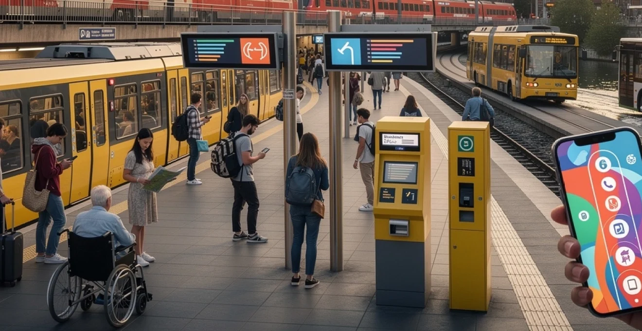
Digital ticketing platforms: BVG app and VBB-App functionality
Digital ticketing has transformed how you can navigate public transport in Berlin, removing the need to find machines or carry exact change. The official BVG app and the VBB-App “Bus & Bahn” both allow you to purchase tickets, plan routes, and receive disruption alerts on your smartphone. After a quick registration and payment setup, you can buy single tickets, day passes, or longer products, which are then displayed as QR codes or in-app tickets that inspectors scan visually. For many users, this feels like carrying a personal ticket machine in their pocket, available 24/7.
Functionally, the BVG app focuses more on Berlin’s urban services and offers an intuitive interface, while the VBB app covers the wider Brandenburg region in greater detail. Both apps integrate real-time data, suggesting the fastest routes and automatically considering delays or disruptions. Digital tickets activate either at purchase or when you manually validate them in the app, so reading the specific conditions before boarding is essential. If your phone battery is low, you should treat your digital ticket like a boarding pass: keep a power bank handy or a backup paper ticket to avoid being caught without proof of payment during a ticket inspection.
Tourist cards: berlin WelcomeCard vs. berlin CityTourCard comparison
For visitors who expect heavy use of public transport in Berlin and plan to explore multiple attractions, tourist cards often offer excellent value. Two major options dominate the market: the Berlin WelcomeCard and the Berlin CityTourCard. Both products combine unlimited travel within chosen zones (AB or ABC) with discounts at museums, tours, and cultural venues, but their partnership networks and discount rates differ. Choosing between them is a bit like selecting a mobile phone plan: the “best” card depends on your usage pattern rather than any universal ranking.
The Berlin WelcomeCard tends to provide a broader range of partner attractions and slightly higher discount percentages, often around 25–50% off entry fees for key museums, sightseeing tours, and entertainment offers. It is available for varying durations, typically 48 hours up to 6 days, and can be purchased as AB or ABC variants, making it ideal if you also plan to visit Potsdam or travel from BER Airport. The Berlin CityTourCard, by contrast, focuses more narrowly on classic tourist highlights but can be marginally cheaper, which may suit travellers with a shorter list of planned visits. Before buying, it is worth listing your top attractions, checking which card includes them, and comparing the combined savings on entrance fees plus public transport in Berlin against the card price.
Monthly and annual subscription options: deutschlandticket integration
Residents, long-stay visitors, and frequent business travellers often benefit from subscription-based public transport tickets rather than repeated short-term purchases. Berlin offers classic Monatskarten (monthly tickets) and Jahreskarten (annual passes) that historically covered specific zones such as AB or BC. Since 2023, the nationwide Deutschlandticket has reshaped this landscape by allowing unlimited travel on local and regional public transport across Germany for a flat monthly fee, currently set at around 49 euros. This subscription includes BVG, S-Bahn, and most Regionalbahn services within the relevant categories, but excludes long-distance ICE, IC, and EC trains.
How does the Deutschlandticket integrate with Berlin’s tariff system in practice? For daily commuting within the city and to nearby Brandenburg towns, it often replaces traditional AB/ABC subscriptions, while still requiring occasional supplements for special services like some express airport buses or long-distance trains. The ticket is typically issued in digital form via apps or smartcards and renews automatically unless cancelled before the monthly deadline. If you are staying in Berlin for several months, comparing the Deutschlandticket to a local AB Monatskarte is essential: with even a modest amount of regional travel, the national ticket frequently offers better value. For employers, subsidised Deutschlandticket schemes have also become a popular benefit, further encouraging public transport in Berlin and beyond.
U-bahn network architecture and station infrastructure
Berlin’s U-Bahn network forms the dense urban backbone of public transport in Berlin, weaving beneath streets and squares like a hidden second city. Ten lines and nearly 175 stations link historic centres, residential quarters, and commercial hubs, ensuring that most residents are rarely more than a short walk from a station. The network’s architecture reflects over a century of urban planning, technological change, and political upheaval, from ornate early 20th-century entrances to minimalist post-war rebuilds and contemporary glass-and-steel interchanges. Understanding how the network is structured helps you interpret maps, anticipate transfer points, and choose routes that minimise walking distances or stairs.
Ten underground lines: route mapping and transfer hubs
The ten U-Bahn lines (U1–U9 and U55, which has now been integrated into U5) fall into two broad families: the narrow-profile lines (Kleinprofil) and the wide-profile lines (Grossprofil). Kleinprofil lines such as U1, U2, U3, and U4 use smaller trains and tunnels, while Grossprofil lines like U5, U6, U7, U8, and U9 operate larger rolling stock. On the map, you will notice that lines often run in long, straight corridors with strategically placed transfer hubs such as Alexanderplatz, Zoologischer Garten, and Wittenbergplatz, where multiple lines intersect. These nodes function like “switchboards” in a telephone network, enabling you to change directions rapidly without leaving the paid area.
Route planning on the U-Bahn becomes easier once you identify the key axes: east–west routes like U1/U3 and U2, and north–south spines like U6 and U8. If you imagine Berlin as a grid, the U-Bahn lines form its main “wires”, while trams and buses fill in the gaps. For many journeys inside Zone A, you can choose between several viable routes with similar travel times, so factors like preferred walking distance, station facilities, or crowd levels can guide your decision. Transfer hubs are generally well signposted, but peak-hour congestion can be intense, so allowing a few extra minutes to navigate corridors and escalators is prudent.
Accessibility standards: lift systems and platform design
Accessibility has become a central design principle for public transport in Berlin, and the U-Bahn network is gradually being retrofitted to meet modern standards. Many major stations now offer step-free access via lifts, ramps, or gently sloped passageways, making them usable for wheelchair users, travellers with luggage, and families with prams. Platforms are increasingly being rebuilt with reduced gaps and level boarding wherever possible, aided by tactile paving and high-contrast signage for visually impaired passengers. While not yet fully barrier-free, the system moves closer to the goal each year through targeted renovations.
Before you travel, you can check accessibility information in the BVG app or on station diagrams, which indicate whether lifts or escalators are available and whether any are currently out of service. This is particularly valuable if you rely on mobility aids or need to plan accessible routes between hotels, conference venues, and tourist sites. Inside trains, priority seating areas are marked clearly, and multilingual announcements support a diverse passenger base. In practice, navigating the U-Bahn with limited mobility can still present challenges at older stations, but combining advance research with flexible routing often yields workable solutions.
Historical preservation: cold war division impact on network development
Berlin’s U-Bahn and S-Bahn networks are living archives of the city’s turbulent 20th-century history. During the Cold War, the division between East and West Berlin led to closed “ghost stations”, truncated lines, and duplicated infrastructure on both sides of the Wall. Trains from West Berlin sometimes passed through dimly lit East Berlin stations without stopping, patrolled by border guards and sealed off from local residents. This unusual configuration left a legacy of parallel routes, underused tunnels, and complex property rights that had to be untangled after reunification.
Post-1990, extensive reconstruction projects reconnected previously separated segments and extended lines to serve newly important urban centres such as Potsdamer Platz and the government quarter. Today, when you change trains at hubs like Friedrichstrasse or ride along the U2 through former border zones, you are also travelling through layers of political history. Preservation efforts balance functional upgrades with conservation of historically significant architecture, resulting in stations where restored tiling and signage sit alongside modern lifts and information displays. For many visitors, exploring the U-Bahn doubles as an informal lesson in Berlin’s urban evolution.
Surface transport systems: trams, buses, and ferry services
While the U-Bahn and S-Bahn handle high-capacity corridors, surface transport completes the public transport in Berlin by reaching streets, neighbourhoods, and waterfronts that rail cannot serve directly. The tram network, concentrated mainly in the former East Berlin, provides frequent service along dense residential and commercial routes, while a comprehensive bus system links almost every corner of the city. In addition, seasonal and regular ferry routes on the Spree, Havel, and surrounding lakes integrate waterborne travel into the VBB tariff system, creating scenic yet practical connections between districts.
Trams are particularly useful in areas like Prenzlauer Berg, Friedrichshain, and Lichtenberg, where they often run on dedicated tracks and enjoy priority at traffic lights, making them faster than buses along similar routes. MetroTram lines, identified by an “M”, typically operate at high frequencies and longer operating hours, acting as surface-level equivalents to U-Bahn lines. Buses range from small neighbourhood shuttles to double-decker city lines that offer excellent sightseeing opportunities along routes such as the famous 100 and 200. Ferry services, meanwhile, can turn an ordinary commute into a short river cruise, especially during summer when locals combine transport with leisure on Berlin’s waterways.
Real-time information systems and mobile applications
In a city as large and complex as Berlin, static timetables alone cannot guarantee a smooth journey. Real-time information systems and mobile applications now play a pivotal role in coordinating public transport in Berlin, providing live updates on delays, disruptions, and platform changes. Digital tools transform journey planning from a fixed schedule into a flexible, adaptive process, much like using a navigation app that reroutes you around traffic jams. For both residents and visitors, learning how to interpret these data streams is almost as important as knowing the basic route map.
VBB live journey planning and disruption notifications
The VBB and BVG apps integrate live data feeds from buses, trams, U-Bahn, S-Bahn, and many regional trains to calculate optimal routes in real time. When an incident disrupts a line, the system automatically suggests alternatives, often combining different modes to keep travel times acceptable. You can set favourites for regular journeys—such as hotel to office or apartment to university—and receive push notifications if upcoming departures are cancelled or significantly delayed. This proactive information helps you decide whether to leave earlier, reroute via a different station, or even switch to bike or car-sharing services if necessary.
Journey planners also display platform numbers, walking times for transfers, and occupancy levels on some services, which can be invaluable during peak hours. If you are new to Berlin, relying on these digital assistants can feel like having a local guide in your pocket, quietly steering you away from bottlenecks. That said, occasional data gaps or sudden disruptions can still occur, so combining app guidance with on-the-ground signage and announcements remains best practice. Treat the system as a collaborative tool: you bring flexibility, and the app provides the latest network intelligence.
Dynamic passenger information systems at stations
At stations and major stops, dynamic passenger information displays complement mobile apps by presenting real-time departure boards that are easy to read at a glance. U-Bahn and S-Bahn platforms typically feature overhead screens showing line numbers, destinations, and countdowns in minutes until the next trains arrive. Many tram and bus stops also have electronic displays that update automatically, adjusting for traffic conditions, operational disruptions, or rerouted services. This combination of fixed and mobile information creates redundancy, so you are less likely to be left guessing when something changes unexpectedly.
Modernisation programmes continue to replace older static signs with digital panels, improving visibility and allowing multilingual messaging during major events or emergencies. Audio announcements, sometimes supplemented with visual alerts, inform passengers about temporary platform changes, construction works, or short-term diversions. In effect, the station becomes an information hub where you can verify what you see in your app against official displays. If the two sources conflict—which occasionally happens during fast-moving incidents—staffed information points at major hubs such as Alexanderplatz, Hauptbahnhof, or Zoologischer Garten can provide clarification.
Third-party navigation apps: citymapper and google transit integration
Alongside official tools, third-party navigation apps like Citymapper and Google Maps have become integral to how many people experience public transport in Berlin. These platforms aggregate open data from VBB and other sources, layering public transport options with walking directions, cycling routes, and even micro-mobility services such as scooters and bike-sharing. For users accustomed to these apps in other cities, switching them on in Berlin offers a familiar interface that bridges the gap between local infrastructure and global user habits. The integration of transit timetables, live positions, and transfer hints often makes it easier to compare different travel modes at a glance.
Citymapper, for example, specialises in multimodal journey planning and can highlight the “easiest” or “healthiest” route, not just the fastest one, which is useful if you want to combine public transport in Berlin with some walking. Google Maps and Apple Maps, meanwhile, offer robust offline map options and extensive point-of-interest databases, helping you align station exits with nearby restaurants, museums, or hotels. While these apps are highly convenient, it is wise to cross-check critical details—such as fare requirements or zone boundaries—against official sources, as commercial platforms may lag behind during fare changes or service reforms. Used together, official and third-party tools create a rich digital ecosystem that makes navigating Berlin’s transport both efficient and surprisingly intuitive, even on your first visit.