Few metropolises worldwide achieve the delicate equilibrium that defines Vancouver’s urban character. Nestled between the Pacific Ocean and the Coast Mountain Range, this Canadian city has evolved into a global exemplar of how high-density development can coexist with pristine natural environments. The integration of wilderness into the urban fabric isn’t merely aesthetic—it represents a fundamental reimagining of what cities can become in an era of climate uncertainty and environmental degradation. With over 2.4 million residents in the metropolitan region, Vancouver demonstrates that population growth need not come at the expense of ecological integrity. The city’s approach to sustainable urbanism has influenced planning frameworks across North America, offering valuable lessons for municipalities grappling with the dual challenges of housing affordability and environmental stewardship.
Vancouver’s success stems from decades of deliberate policy choices that prioritised green infrastructure alongside commercial development. The result is a city where you can stand in the heart of the downtown core and still glimpse mountain peaks through glass towers, where cycling paths connect residential neighbourhoods to wilderness trails, and where urban wildlife thrives in carefully maintained ecological corridors. This isn’t accidental—it’s the product of innovative planning strategies, architectural ingenuity, and a collective commitment to preserving the natural systems that make the region habitable.
Vancouver’s geographic position within the coastal temperate rainforest biome
Vancouver occupies a unique ecological niche within one of the planet’s rarest and most biologically productive ecosystems. The coastal temperate rainforest biome extends from northern California to southeast Alaska, representing less than one percent of Earth’s land surface. This narrow band of temperate rainforest receives between 1,400 and 4,000 millimetres of annual precipitation, creating conditions that support remarkable biodiversity and carbon sequestration capacity. The city itself sits within the Coastal Western Hemlock biogeoclimatic zone, characterised by towering western red cedar, Douglas fir, and hemlock trees that once dominated the landscape.
Ecological significance of the pacific northwest coastal region
The Pacific Northwest coastal region functions as a critical corridor for numerous species undertaking long-distance migrations. Each autumn, millions of waterfowl and shorebirds traverse the Pacific Flyway, with the Fraser River Delta serving as an essential staging area where birds rest and refuel before continuing their journeys. The marine environment surrounding Vancouver supports five species of Pacific salmon, whose annual spawning runs have sustained indigenous communities for millennia and continue to provide vital nutrients to forest ecosystems through their decomposition. These salmon runs create a nutrient transfer from ocean to forest that enriches riparian zones and supports everything from bears to eagles to ancient trees.
The region’s complex geological history has created diverse microclimates within relatively small geographic areas. Orographic lift caused by the Coast Mountains produces heavy rainfall on windward slopes whilst creating rain shadow effects in sheltered valleys. This variability supports an extraordinary range of plant communities, from salt marshes at sea level to alpine meadows above the treeline. The interplay between marine and terrestrial environments generates ecological productivity that rivals tropical rainforests in terms of biomass per hectare.
Stanley park’s 405-hectare urban forest ecosystem
Stanley Park stands as Vancouver’s ecological centrepiece—a largely intact coastal rainforest ecosystem existing mere minutes from the city’s financial district. Designated in 1888, this 405-hectare peninsula contains approximately half a million trees, some exceeding 76 metres in height and 800 years in age. The park’s forest canopy provides critical habitat for over 230 bird species, including great blue herons, bald eagles, and numerous migratory songbirds. What makes Stanley Park particularly remarkable is its functional ecosystem—this isn’t merely a collection of trees but a living forest with intact nutrient cycles, natural regeneration, and complex food webs.
The park’s shoreline encompasses diverse intertidal zones where visitors can observe purple sea stars, barnacles, and various crab species during low tide. These transitional areas between land and sea represent some of the most biologically productive zones on the planet, supporting juvenile fish populations and providing feeding grounds for shorebirds. The famous Seawall pathway circumnavigates the park, offering 9 kilometres of waterfront access whilst minimising impact on sensitive coastal habitats
While storms and king tides periodically test the park’s resilience, adaptive management strategies—such as selective tree replacement, shoreline reinforcement with natural materials, and invasive species control—aim to preserve Stanley Park as a functioning rainforest in the heart of the city. For visitors and residents alike, it offers a daily reminder that Vancouver’s liveability is inseparable from the health of its surrounding ecosystems.
The fraser river delta’s migratory bird sanctuary network
South of downtown Vancouver, the Fraser River Delta forms one of the most important estuarine systems on the Pacific coast of North America. Recognised as a Ramsar Wetland of International Importance and part of the Western Hemisphere Shorebird Reserve Network, this low-lying landscape of mudflats, salt marshes, and agricultural fields supports millions of birds each year. Species such as western sandpipers, snow geese, and dunlin depend on the delta’s rich feeding grounds during their migrations along the Pacific Flyway.
Four federally designated Migratory Bird Sanctuaries—George C. Reifel, Alaksen National Wildlife Area, Roberts Bank, and Sturgeon Bank—form a connected mosaic of protected habitat within this working landscape. Despite pressures from port expansion, industrial development, and sea level rise, coordinated conservation efforts have helped maintain critical stopover and overwintering sites. For urban residents, the delta functions as a living classroom, illustrating how large-scale ecological processes unfold within a short drive of the city centre.
Balancing economic activity with biodiversity protection in the Fraser Delta is an ongoing challenge. Port infrastructure, dredging, and shoreline armouring can disrupt sediment dynamics and eelgrass beds that underpin the entire food web. In response, environmental assessments increasingly incorporate cumulative effects on the migratory bird sanctuary network, and restoration projects target tidal marsh re-creation, dyke setbacks, and agricultural practices that are more bird-friendly. The delta illustrates, perhaps more starkly than anywhere else in Metro Vancouver, how decisions made today will determine whether future generations can still witness skies filled with migrating birds.
North shore mountains: grouse, cypress, and seymour provincial parks
Rising sharply across Burrard Inlet, the North Shore Mountains form a dramatic backdrop to Vancouver’s skyline and a crucial component of the region’s ecological infrastructure. Grouse, Cypress, and Mount Seymour provincial parks protect large tracts of montane and subalpine forest, acting as both recreational playgrounds and biodiversity reservoirs. These forested slopes store vast amounts of carbon, regulate local microclimates, and serve as headwaters for streams that flow through North Vancouver and West Vancouver neighbourhoods.
For residents, the accessibility of these mountains is remarkable: within 30–45 minutes of leaving downtown, you can be hiking among old-growth stands, alpine lakes, and heather meadows. Wildlife including black bears, cougars, and northern goshawks still navigate these landscapes, highlighting the importance of maintaining habitat connectivity between high-elevation refuges and lower-lying river valleys. In winter, the same terrain supports ski resorts and snowshoe trails, demonstrating how recreational demand and conservation objectives must be balanced carefully.
Climate change introduces new complexities to managing the North Shore parks. Warmer winters and shifting snowpacks affect water supply, slope stability, and the timing of ecological processes such as salmon spawning and forest regeneration. Increased visitation also brings risks of trail erosion, wildlife habituation, and vegetation trampling. Provincial and municipal partners are responding with measures like seasonal trail closures, educational campaigns, and infrastructure upgrades that concentrate use in less-sensitive zones, aiming to protect these mountain ecosystems while keeping them accessible to the urban population that depends on them.
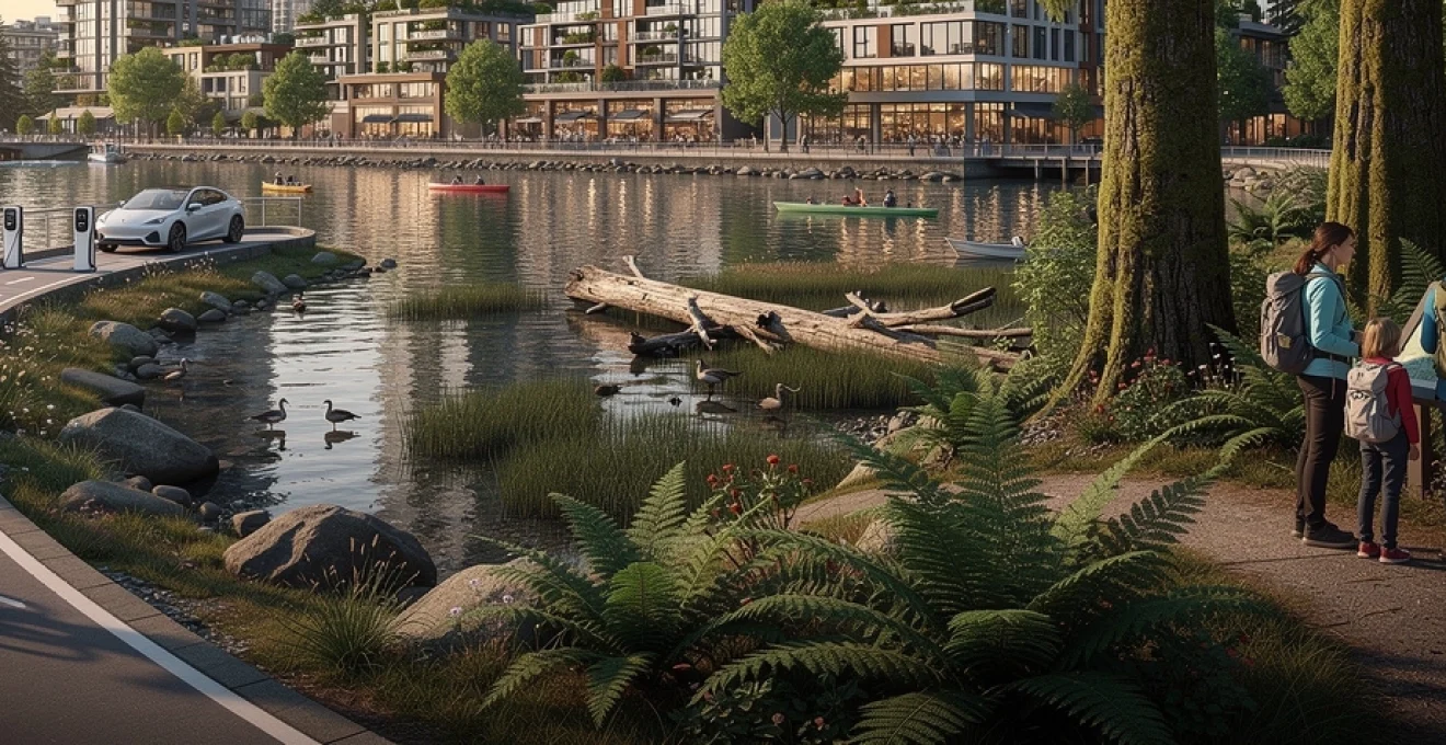
Urban planning strategies integrating green infrastructure throughout metro vancouver
Vancouver’s urban planning approach treats green infrastructure not as an amenity but as essential civic hardware, comparable to roads or sewer lines. Instead of pushing nature to the city’s fringes, planners have woven parks, greenways, rain gardens, and urban forests into the everyday streetscape. This strategy recognises that in a coastal temperate rainforest city, managing water, vegetation, and habitat is central to both climate resilience and quality of life.
By integrating ecological systems into zoning bylaws, community plans, and development approvals, the city has created a framework where private development and public space enhancements reinforce one another. Green roofs, permeable pavements, and bioswales capture stormwater before it overwhelms aging pipes, while linear parks and greenways provide safe, low-carbon routes for walking and cycling. The result is a metropolitan region where you can move through continuous corridors of planted spaces, even while living in some of the densest neighbourhoods in Canada.
Greenways network connecting 28 neighbourhoods across the city
Vancouver’s Greenways Network is a cornerstone of its green infrastructure strategy, designed to link 28 neighbourhoods through a series of linear routes prioritising pedestrians and cyclists. Unlike traditional parks, greenways follow existing streets and utility corridors, retrofitted with wider sidewalks, separated bike lanes, street trees, and traffic-calming measures. For residents, these routes transform routine trips—to work, school, or the local shop—into pleasant, low-stress journeys through greenery.
The Arbutus Greenway, a former rail corridor stretching roughly nine kilometres from False Creek to the Fraser River, exemplifies this approach. Interim pathways now accommodate walkers, cyclists, and mobility devices, with long-term plans for pollinator meadows, community gardens, and cultural spaces along the route. In eastern Vancouver, the Central Valley Greenway connects downtown to neighbouring municipalities, demonstrating how regional collaboration can extend active transportation networks beyond city boundaries.
From a climate adaptation perspective, the greenways network functions like a series of “green sponges” across the urban fabric. Street trees and planted boulevards intercept rainfall, reduce heat island effects, and improve air quality, while permeable surfaces allow water to infiltrate rather than rush into storm drains. For planners elsewhere asking how to retrofit car-oriented grids, Vancouver’s greenways provide a tangible model: reallocate road space, layer in vegetation, and give priority to people on foot and bike.
False creek’s waterfront revitalisation and habitat restoration projects
Once an industrial inlet lined with sawmills, shipyards, and contaminated fill, False Creek has undergone a profound transformation over the past four decades. The area’s revitalisation—catalysed by Expo 86 and subsequent redevelopment—has turned a polluted working harbour into a mixed-use waterfront neighbourhood where residential towers, parks, and marinas coexist with restored intertidal habitats. Yet beneath the visible urban design lies a more subtle story of ecological repair.
Habitat enhancement projects along False Creek’s shores have introduced riprap revetments with habitat niches, floating vegetated islands, and experimental eelgrass plantings. These features support juvenile salmon, herring, and invertebrate communities, helping to re-establish food webs disrupted by decades of fill and bulkheads. While water quality challenges persist—particularly related to combined sewer overflows and legacy contamination—the inlet now supports greater biodiversity than at any point in recent industrial history.
Public access initiatives, such as the seawall promenade and small-scale ferry services like the Aquabus, allow residents and visitors to experience False Creek’s evolving ecology up close. Interpretive signage and citizen science programs invite people to notice herring spawn or seasonal bird migrations, strengthening the connection between urban dwellers and the marine environment. In many ways, False Creek functions as a living laboratory for how waterfront revitalisation can integrate habitat restoration, recreation, and high-density living.
Urban forest strategy: 150,000 tree canopy cover target by 2050
Recognising that trees are critical infrastructure in a warming climate, Vancouver has adopted an Urban Forest Strategy that sets an ambitious canopy cover target for 2050. After decades of tree loss due to development pressure, utility conflicts, and pests, the city is working to reverse the trend by planting and protecting approximately 150,000 new trees. These efforts aim not only to boost canopy percentage but also to ensure that benefits such as shade, cleaner air, and stormwater interception are distributed more equitably across neighbourhoods.
Urban foresters focus on diversifying species to build resilience against diseases and climate stress, moving away from monocultures toward mixed plantings of native and climate-adapted trees. In many streets, narrow boulevards are redesigned to accommodate larger soil volumes, ensuring that saplings can grow into mature canopy trees rather than remaining stunted. Community tree-planting events, schoolyard greening projects, and yard tree rebate programs invite residents to participate directly in expanding the urban forest.
From an economic standpoint, investing in canopy cover can be likened to upgrading a city’s “natural air-conditioning system.” Trees moderate peak summer temperatures, reducing cooling demand in buildings, while also extending the lifespan of asphalt and other infrastructure by shading surfaces. As extreme heat events become more frequent across the Pacific Northwest, the urban forest will play an increasingly central role in protecting vulnerable populations and maintaining liveability in dense districts.
LEED platinum certification standards in vancouver’s development framework
Vancouver has long been an early adopter of green building standards, embedding performance requirements into its development approvals. Many of the city’s most prominent projects target or achieve LEED Gold and LEED Platinum certification, reflecting a shift from voluntary sustainability features to baseline expectations. For developers, this means integrating high-efficiency mechanical systems, low-impact materials, and robust energy modelling into project design from the outset.
The city’s Green Buildings Policy leverages density bonuses, expedited permitting, and other incentives to encourage best-practice performance. In practice, this leads to towers with high-performance facades, extensive bike storage, green roofs, and rainwater management systems that exceed provincial code. Public buildings—from neighbourhood branches of the public library to community centres—often serve as showcases, demonstrating how LEED Platinum facilities can minimise energy use, integrate daylighting, and provide healthy indoor environments.
While certification frameworks are not a panacea, they create a common language between architects, engineers, planners, and investors. They also help quantify benefits such as reduced greenhouse gas emissions, lower operating costs, and improved occupant comfort. As standards evolve to align more closely with net-zero and embodied carbon targets, Vancouver’s experience with LEED offers a stepping stone toward even more stringent performance outcomes.
Architectural innovation: vancouverism and high-density sustainable development
“Vancouverism” has become shorthand for a distinctive approach to high-density urban design that combines slender residential towers with active, pedestrian-friendly podiums. Developed in response to the city’s constrained geography and strong public demand for view protection, this model prioritises livability within dense urban cores. Rather than creating monolithic blocks, architects and planners arrange towers to preserve sunlight, mountain vistas, and access to public open space.
At street level, Vancouverism emphasises fine-grained retail, townhouses, and community amenities that activate sidewalks and reduce reliance on cars. Above, residential units maximise daylight and natural ventilation, with generous balconies providing semi-private outdoor spaces. This blend of vertical living and human-scaled public realm has been widely studied and emulated by cities seeking to reconcile growth with quality of life and climate goals.
Slender tower design methodology preserving view corridors
One of the hallmarks of Vancouverism is the city’s strict approach to protecting view corridors—carefully mapped sightlines that preserve public views of mountains, water, and iconic features. To maintain these vistas, zoning regulations limit building heights and require slender tower forms with small floorplates, often around 6,500–7,500 square feet. This methodology ensures that towers allow sunlight and views to “slip” between them, preventing the canyon effect common in many high-rise districts.
From a sustainability perspective, slender towers also enable more units to enjoy natural light and cross-ventilation, reducing dependence on artificial lighting and mechanical cooling. Balconies and operable windows encourage indoor–outdoor living and passive climate control, which is especially effective in Vancouver’s mild coastal climate. The trade-off is that structural and mechanical systems must be carefully engineered to handle wind loads and vertical circulation in narrower volumes.
For residents, the benefits of this design approach are tangible: panoramic views, generous sky exposure on streets, and access to pocket parks and plazas that punctuate the urban grid. For planners elsewhere pondering how to orient new high-rises, Vancouver’s view-based zoning shows that treating the skyline as shared public space—not just development potential—can yield both aesthetic and environmental dividends.
Coal harbour and yaletown: case studies in mixed-use urbanism
Coal Harbour and Yaletown, two former industrial districts on the downtown peninsula, illustrate how Vancouverism principles translate into complete neighbourhoods. In Coal Harbour, railyards and shipping terminals have given way to a waterfront promenade, residential towers, and park spaces that connect seamlessly to Stanley Park’s Seawall. Mixed-use podiums host cafes, childcare facilities, and local services, ensuring that daily needs are within walking distance for residents.
Yaletown’s evolution from warehouse district to high-density residential enclave follows a similar arc, with heritage brick buildings repurposed for offices and restaurants amid new glass towers. Narrow streets, preserved loading docks, and small plazas create a distinctive sense of place, while the neighbourhood’s parks and dog runs serve families living in apartments. Both districts prioritise walkability, transit access, and active frontages, demonstrating how to retrofit brownfields into low-carbon communities.
These case studies also highlight challenges: ensuring housing affordability, preventing excessive short-term rentals, and maintaining diversity of uses over time. Nevertheless, Coal Harbour and Yaletown show that dense, mixed-use urbanism can deliver high-quality public spaces and waterfront access while limiting sprawl. For visitors, they provide a tangible example of how a city can turn its industrial legacy into a framework for sustainable living.
Passive house standard adoption in vancouver’s housing stock
In recent years, Vancouver has gone beyond conventional green building certification by championing the Passive House standard, which focuses on ultra-low energy demand through super-insulation, airtightness, and heat-recovery ventilation. The city has introduced incentives and, in some cases, requirements for new multi-family and laneway homes to meet or approach Passive House performance levels. This shift recognises that operational energy use must be dramatically reduced to meet long-term climate targets.
Passive House buildings in Vancouver—ranging from social housing projects to market condominiums—demonstrate that high performance is compatible with contemporary urban design. Residents benefit from stable indoor temperatures, exceptional air quality, and lower utility bills, even during heatwaves or cold snaps. Architects, meanwhile, must pay closer attention to thermal bridging, envelope detailing, and window performance, often collaborating more closely with energy modellers and mechanical engineers.
As construction costs rise, questions naturally emerge: is the additional investment in Passive House worth it? Early evidence suggests that when life-cycle costs and avoided emissions are considered, the answer is increasingly yes. For a coastal city expecting a long building lifespan and evolving climate conditions, designing to rigorous standards today can be likened to buying climate insurance for decades to come.
Transportation infrastructure balancing urban mobility and environmental preservation
Vancouver’s transportation strategy is anchored in a simple but ambitious hierarchy: walking, cycling, and transit are prioritised over private automobiles. This approach seeks to reduce greenhouse gas emissions, improve public health, and conserve land that would otherwise be paved for roads and parking. By integrating land use planning with transit investments, the city and region have created corridors where high-density development supports frequent service—and vice versa.
The result is a metropolitan area where a significant share of trips are already made by sustainable modes, and where future growth is planned around transit-oriented development nodes. Compact neighbourhoods, limited freeway infrastructure within the city proper, and an expanding rapid transit network all contribute to lower per-capita emissions compared to many North American counterparts. Yet the work is far from finished, as congestion, affordability, and regional equity remain active debates across Metro Vancouver.
Translink’s rapid transit expansion: millennium, canada, and expo lines
TransLink, the regional transportation authority, oversees an integrated system of buses, rapid transit, and commuter rail that connects Vancouver to its neighbouring municipalities. The SkyTrain network—comprising the Expo, Millennium, and Canada Lines—forms the backbone of this system, offering frequent, automated service along key urban corridors. Stations are deliberately clustered with mid- to high-density housing, offices, and retail, supporting car-free and car-light lifestyles.
The Canada Line, opened in 2009, links downtown Vancouver to the airport and the City of Richmond, providing a fast, low-emission alternative to driving along congested arterials. Extensions to the Millennium Line toward the University of British Columbia and further into the eastern suburbs are planned or underway, promising to connect major educational and employment hubs more sustainably. Each new station becomes an opportunity to reimagine surrounding land uses in favour of compact, mixed-use forms.
From a climate perspective, rapid transit expansion reduces not only tailpipe emissions but also the embodied carbon associated with sprawling road networks and dispersed development. For residents deciding where to live or invest, proximity to SkyTrain stations has become a key factor, signalling the growing recognition that convenient, reliable transit is integral to urban quality of life.
Separated cycling lane network: 30-kilometre protected route system
Vancouver’s separated cycling lane network has transformed how people move through the city, making cycling a viable option for commuters, families, and older adults. Approximately 30 kilometres of protected routes—such as the Dunsmuir, Hornby, and Burrard corridors—provide physical separation from motor vehicle traffic using curbs, planters, or elevation differences. These lanes connect to neighbourhood bikeways and greenways, forming a coherent system that reduces the stress and risk traditionally associated with urban cycling.
The impact on mode share has been significant, with cycling trips increasing steadily as infrastructure expanded. Businesses along protected routes, once wary of reduced parking, have often discovered that increased foot and bike traffic can boost local commerce. For residents, the network means you can ride from residential areas to downtown, universities, and major parks without navigating high-speed traffic lanes.
The analogy often used by planners is that safe cycling lanes function like “training wheels” for the city: once people feel protected, they are far more willing to try biking for everyday trips. As e-bikes make longer and hillier journeys less daunting, the value of a connected, protected network will only grow—especially in a region where mild winters allow year-round riding.
Electric vehicle charging infrastructure and zero-emissions vehicle adoption rates
While reducing car dependency is a core objective, Vancouver also recognises that many residents will continue to rely on vehicles for certain trips. To decarbonise this segment, the city and province have aggressively supported electric vehicle (EV) adoption through incentives, regulations, and infrastructure investment. Public charging stations are now common in parkades, curbside locations, and commercial centres, while new multi-unit residential buildings are typically required to be “EV-ready” with wiring to parking stalls.
British Columbia consistently records some of the highest zero-emissions vehicle adoption rates in North America, with EVs representing a growing share of new car sales. This trend is reinforced by provincial mandates that phase out the sale of new internal combustion engine vehicles over the coming decades. For apartment and condo dwellers—a large portion of Vancouver’s population—reliable access to charging at home or near home is crucial, prompting building retrofits and strata-level planning.
As the grid integrates more renewable energy, the climate benefits of EVs will increase further. However, planners remain mindful that electrification alone will not solve congestion, land use, or equity challenges. The broader strategy continues to prioritise walking, cycling, and transit, with EVs seen as one component of a multi-layered approach to low-carbon mobility.
Climate action strategy: vancouver’s 2040 carbon neutral roadmap
Vancouver’s climate policies are guided by a long-term roadmap that aims to achieve significant emissions reductions by 2030 and net-zero operations by mid-century. The city’s Climate Emergency Action Plan sets sector-specific targets for buildings, transportation, and waste, recognising that each requires tailored tools. Key measures include phasing out fossil fuel heating in new buildings, tightening energy codes for existing stock, and continuing to shift mode share away from private vehicles.
By 2040, the roadmap envisions a city where most trips are made by walking, cycling, or transit; where buildings are heated and cooled with electricity or renewable energy; and where organic waste is diverted from landfills to produce compost or renewable natural gas. Carbon pricing, green bonds, and partnerships with utilities help finance the necessary infrastructure upgrades, while community engagement ensures that policies reflect local priorities and do not disproportionately burden vulnerable groups.
Of course, roadmaps are only as effective as their implementation. Progress reports, third-party audits, and transparent data dashboards help track whether Vancouver is on pace to meet its milestones. For other cities seeking to chart their own course, Vancouver’s experience underscores a key lesson: integrating climate action across departments—from planning and engineering to parks and housing—is essential if ambitious targets are to translate into real-world change.
Recreational access points: trail systems connecting urban core to wilderness areas
One of Vancouver’s defining qualities is how seamlessly recreation is embedded into everyday life. Rather than requiring long drives to reach nature, the city’s trail systems stitch together waterfronts, forests, and mountain foothills directly from the urban core. These corridors do double duty: they provide low-carbon transportation options while also supporting mental health, social connection, and ecological literacy.
From the perspective of sustainable urban living, accessible trail networks act like pressure valves, allowing residents to decompress in natural settings without leaving a heavy environmental footprint. Whether you’re cycling around the downtown peninsula, hiking along the North Shore, or taking an evening stroll through Pacific Spirit Regional Park, the city’s design makes it easy to step out of your daily routine and into green space.
Seawall circumnavigation route: 28-kilometre waterfront pathway
The Seawall is perhaps Vancouver’s most iconic piece of recreational infrastructure—a continuous, approximately 28-kilometre waterfront pathway encircling the downtown peninsula and extending into neighbouring districts. Originally built as a protective barrier for Stanley Park’s shoreline, it has evolved into a multi-use route that accommodates walkers, runners, cyclists, and wheelchair users with separated lanes in many sections. The experience of circumnavigating the Seawall offers a constantly shifting panorama of mountains, ocean, beaches, and city skyline.
From an urban design standpoint, the Seawall illustrates how a single linear project can knit together disparate public spaces into a coherent whole. It links parks, plazas, beaches, and transit hubs, enabling residents to move along the waterfront without interacting much with vehicular traffic. Tourists often experience Vancouver primarily through this route, gaining an intuitive sense of the city’s relationship to the sea and mountains.
As sea level rise and storm surges become more pronounced, parts of the Seawall will require adaptation—whether through elevation, setback, or transformation into more flexible, nature-based shorelines. These challenges also present opportunities: reimagined sections could incorporate restored intertidal zones, floating walkways, or terraced salt marshes, maintaining public access while enhancing coastal resilience.
Baden-powell trail: 48-kilometre trans-mountain hiking corridor
On the North Shore, the Baden-Powell Trail offers a very different but equally compelling experience of Vancouver’s geography. Stretching roughly 48 kilometres from Horseshoe Bay in the west to Deep Cove in the east, this rugged hiking corridor traverses steep forested slopes, creeks, and viewpoints above the urban area. Access points at multiple trailheads mean residents can tackle short sections after work or devote a full day to longer segments.
The trail showcases the rapid transition from suburb to wilderness that characterises Metro Vancouver. Within minutes of leaving residential streets, hikers find themselves among moss-draped trees, rushing streams, and rocky outcrops with expansive views. Popular segments, such as the approach to Quarry Rock or the climb near Grouse Mountain, underscore the need for careful trail maintenance and visitor management to protect sensitive ecosystems from overuse.
For planners and conservationists, the Baden-Powell functions as both a recreational asset and a wildlife movement corridor. Keeping its surrounding forests intact helps maintain connectivity between lower elevation habitats and higher alpine zones, which is increasingly critical as species shift their ranges in response to climate change.
Pacific spirit regional park’s 73-kilometre trail network
On the city’s western edge, Pacific Spirit Regional Park encompasses more than 750 hectares of forest, beaches, and ravines surrounding the University of British Columbia. Within this protected area, roughly 73 kilometres of trails offer options for walking, running, horseback riding, and cycling, with both gravel and natural-surface routes. For many west-side residents and students, the park serves as a daily dose of wilderness, accessible by foot, bike, or bus.
The park’s mixed second-growth and remnant old-growth stands provide habitat for owls, songbirds, small mammals, and amphibians, while its coastal bluffs and beaches support intertidal communities and migratory birds. Seasonal closures and designated off-leash zones aim to balance recreational demand with ecological protection, acknowledging that off-trail shortcuts and uncontrolled pets can have outsized impacts on sensitive flora and fauna.
From a climate adaptation lens, Pacific Spirit Park acts as a local carbon sink and a cool refuge during heat events. Its dense canopy can lower air temperatures by several degrees compared to surrounding urban areas, offering a tangible demonstration of how urban-adjacent forests contribute to public health. The park thus embodies the idea that in a city like Vancouver, conservation and recreation are not competing priorities but mutually reinforcing goals.
Capilano suspension bridge and lynn canyon ecological reserve access
Capilano Suspension Bridge and Lynn Canyon offer two of the region’s most dramatic portals into temperate rainforest environments, each spanning deep river gorges carved into the North Shore Mountains. The privately operated Capilano Suspension Bridge Park combines its 137-metre-long bridge with canopy walkways and interpretive exhibits, introducing visitors to the cultural and ecological history of the area. Lynn Canyon, operated by the District of North Vancouver, provides a more low-key but equally striking experience, with free access to trails, waterfalls, and forest viewpoints.
Both sites highlight the power of immersive experiences in fostering appreciation for old-growth and second-growth forests. Standing 70 metres above a rushing river, you gain an immediate, visceral sense of the forces that shape this landscape and the importance of intact watersheds for salmon, drinking water, and biodiversity. Interpretive signage, guided tours, and partnerships with local First Nations help contextualise these experiences within longer narratives of stewardship and change.
High visitor numbers at these attractions also underscore the responsibilities that come with popularity. Erosion control, waste management, and safety infrastructure must keep pace with demand, while nearby communities manage parking, traffic, and noise. When handled thoughtfully, however, sites like Capilano and Lynn Canyon function as gateways: they inspire residents and travellers to see Vancouver not just as a scenic backdrop, but as an interconnected web of ecosystems in which urban life and wild nature are in constant dialogue.